Integrated Sustainability Appraisal - Scoping Report (ISA)
Chapter 4 Baseline Information
4.1 Baseline information provides the context for assessing the sustainability of proposals in the LDP and it provides the basis for identifying trends, predicting the likely effects of the plan and monitoring its outcomes. The requirements for baseline data vary widely, but it must be relevant to environmental, social and economic issues, be sensitive to change and should ideally relate to records which are sufficient to identify trends.
4.2 Schedule 2 of the SEA Regulations (Wales) requires data to be gathered on biodiversity, population, human health, flora, fauna, soil, water, air, climatic factors, material assets, cultural heritage including architectural and archaeological heritage, landscape and the inter-relationship between the above factors. As an integrated SA and SEA is being carried out as part of a wider ISA process, baseline information relating to other sustainability topics has also been included; for example information about housing, education, deprivation, Welsh language, transport, energy, waste and economic growth.
4.3 The collection and interpretation of baseline information is a valuable way in which we can gain an understanding and strategic overview of what kind of place Anglesey is. Given the breadth of topics covered, it reflects on the current state of the environment, the economy, societal issues and those characteristics which are most likely to be affected by the plan. This understanding allows us to not only consider the likely effects and impacts of the LDP but also how it can make a positive contribution towards the overall quality of human life and social, economic and environmental wellbeing.
4.4 This chapter presents the baseline information for Anglesey. The data referred to have been chosen primarily for regularity and consistency of collection, in order to enable trends in the baseline situation to be established, and also subsequent monitoring of potential sustainability effects. The baseline information will be reviewed and updated at each stage of the LDP in order to reflect the most up-to-date evidence available.
4.5 A number of maps have been prepared to illustrate the baseline information, as referenced throughout this chapter. The maps can be found at the end of Chapter 4.
Environmental Baseline Information
Climate change
4.6 The UK Climate Change Risk Assessment21 found that average temperatures over land across Wales have increased, with the decade from 2005-2014 being 0.9oC warmer than the 1961-1990 average. In terms of future predicted changes, the latest set of projections for Wales comes from the 2018 UK Climate Projections (see Table 4.1 and Table 4.2)22.
Table 4.1: UKCP18 2040-2059 Mean temperature - Summer changes compared to 1981-2000
|
10th percentile |
50th percentile |
90th percentile |
|
|
RCP8.5 |
0 - 1°C |
2 - 3°C |
3 - 4°C |
|
RCP6.0 |
0 - 1°C |
1 - 2°C |
2 - 3°C |
|
RCP4.5 |
0 - 1°C |
1 - 2°C |
2 - 3°C |
|
RCP2.6 |
0 - 1°C |
1 - 2°C |
2 - 3°C |
Table 4.2: UKCP18 2040-2059 Rainfall - Winter changes compared to 1981-2000
|
10th percentile |
50th percentile |
90th percentile |
|
|
RCP8.5 |
-10 - 0% |
10 - 20% |
10 - 40% |
|
RCP6.0 |
-10 - 0% |
0 - 10% |
20 - 30% |
|
RCP4.5 |
-10 - 0% |
0 - 20% |
20 - 30% |
|
RCP2.6 |
-10 - 0% |
0 - 10% |
20 - 30% |
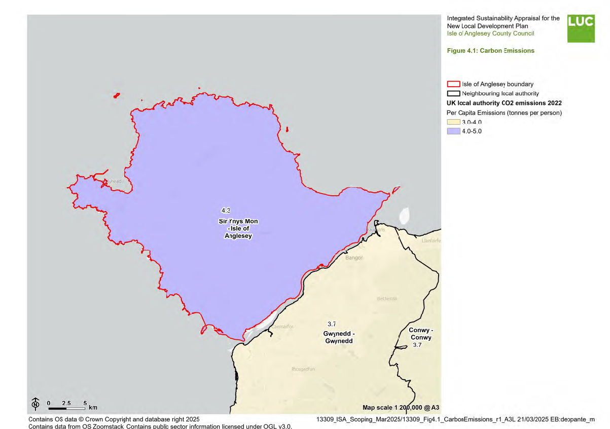
4.7 Reducing CO2 emissions is a key component of tackling climate change. After declaring a climate emergency in September 2020, Isle of Anglesey County Council committed to reducing energy consumption and CO2 emissions across its properties, with a goal of becoming carbon neutral by 203023. The most recent available CO2 emissions estimates (2022)24 show that Wales has higher emissions per capita than most other regions due to it having the highest emissions per capita from the industrial sector (2.9 tCO2e per person), reflecting its higher level of industrial installations (see Figure 4.1).
However, as shown in Table 4.3, in comparison to the rest of Wales, Anglesey has had consistently lower emissions per capita since 2005. CO2 emissions on Anglesey have fallen at a slightly faster rate than across Wales as a whole, with a reduction of 85.33% (compared to 52.27% nationally) between 2005 and 202225.
Table 4.3: CO2 Emissions per Capita in the Isle of Anglesey and Wales 2005-2022
|
Year |
CO2 Emissions per Capita in tonnes |
|
|
Isle of Anglesey |
Wales |
|
|
2005 |
10.7 |
11.1 |
|
2006 |
10.7 |
11.2 |
|
2007 |
10.5 |
11.0 |
|
2008 |
9.8 |
10.6 |
|
2009 |
8.7 |
9.1 |
|
2010 |
7.3 |
10.1 |
|
2011 |
6.5 |
9.1 |
|
2012 |
6.8 |
8.9 |
|
2013 |
6.4 |
9.7 |
|
2014 |
5.9 |
9.2 |
|
2015 |
5.7 |
8.7 |
|
2016 |
5.3 |
8.0 |
|
2017 |
5.1 |
7.8 |
|
2018 |
5.0 |
7.5 |
|
2019 |
4.9 |
7.4 |
|
2020 |
4.3 |
6.7 |
|
2021 |
4.6 |
7.1 |
|
2022 |
4.3 |
6.5 |
4.8 The Government produces annual figures on land use, land use change and forestry (LULUCF) which give an insight on the value of land in the Isle of Anglesey as terrestrial sinks which can remove CO2 from the air. These figures account for the net emissions in the County from areas of forest, crops, grassland, settlements, peatland, bioenergy and 'other' emissions that do not fall into any of these categories. Between 2005 and 2022 there has been a decrease in the net LULUCF emissions in the Isle of Anglesey from -9.7kt to - 17.8kt. While net emissions associated with settlements in the County have fallen from 16.4kt to 10.6kt, cropland from 16.4kt to 10.6kt and those associated with 'other' emissions from 4.1kt to 3.7kt during this period, net emissions from forest land have risen from -49.0kt to -34.6kt and grassland associated net emissions from 26.7kt to 25.2kt. This reflects the fact that the area of the Isle of Anglesey covered by forests and grassland which can act as a sink to benefit CO2 storage has fallen during this period. Emissions associated with peatland have remained constant, accounting for 0.5kt of emissions and there have consistently been no emissions from bioenergy26.
4.9 Energy consumption and generation is also an important factor in reducing CO2 emissions. In 2017, the Welsh Government announced a target of meeting 70% of its energy demand from Welsh renewable energy sources by 2030. The latest figures27 show that as a result of falling fossil gas generation, renewable energy sources contributed 34% of all electricity generated in Wales in 2023.
4.10 Wales generated a total of 23.2 TWh of electricity in 2023, 7.8 TWh of which came from renewables and 15.4 TWh from fossil fuels (from 21.1 TWh in 2022, closest to the lowest levels in the last two decades). Wales is estimated to have consumed in the order of 14.8 TWh of electricity in 2023. This means that Wales generated almost twice as much electricity as it consumed. Consequently, Wales remains a net exporter of electricity to the rest of Great Britain, Ireland and the wider European electricity network28.
4.11 68% of all Welsh renewable electricity generation is from onshore and offshore wind, with most of the remainder from solar PV and biomass electricity generation29.
4.12 As of the end of 2023, Anglesey had a total of 4,765 renewable electricity installations. The majority of these were photovoltaic systems (4,725) with an installed capacity of 97.9MW, followed by onshore wind installations (37) with an installed capacity of 39.0MW and a small number of individual sites utilising anaerobic digestion, landfill gas and plant biomass, which contribute to a combined installed capacity of 3.1MW30. This totals 140MW of installed capacity. According to the most recent 'Energy Generation in Wales' report, the Isle of Anglesey contributes to around 2% of Wales' annual renewable energy generation31.
4.13 Recently, Anglesey announced its ambitions for 'Energy Island', a strategic initiative aimed at transforming Anglesey into a centre for low-carbon energy production, supporting economic growth, job creation and Wales' net-zero commitments. The programme seeks to attract public and private sector investment to develop a range of renewable and low-carbon energy projects, including nuclear power, hydrogen and onshore and offshore wind development32.
4.14 A key focus of the project is tidal and marine energy, particularly through the Morlais tidal energy project. This initiative has the potential to generate up to 240MW of renewable electricity, providing enough power for over 180,000 homes. However, the project extends beyond energy generation, serving as a testbed for innovative tidal energy technologies. The Morlais project aims to facilitate the development, deployment and optimisation of tidal energy systems from a range of international companies, fostering innovation in efficient and sustainable tidal power extraction33.
4.15 Car ownership and the number of people with one or more cars per household have risen on Anglesey between 2011 and 2021, by 3.1%. Car ownership rates in 2021 were above the Welsh average, with an average of 85% of households on Anglesey with one or more car / van, compared to 80% in Wales34. This percentage is higher in more rural areas of Anglesey, reaching 95% of households with car ownership around Llanfairynghornwy and Llanrhwydrys and is as low as 42% of households with car ownership in Lower Super Output Areas in more urbanised areas such as Holyhead35.
4.16 There are 86 total public electric vehicle charging devices available on Anglesey, which equates to 124.5 devices per 100,000 people. There are only 8 rapid devices on Anglesey. Anglesey is in the 20% to <40% category of all local authorities for the number of total devices, but in the top 20% for devices per 100,000 people36. Up to March 2024, the network has provided enough charging to save 221 tonnes of travel carbon emissions, which equates to 1327 trees - a significant contribution to improving the environment and towards net zero carbon37.
Flood risk
4.17 Climate change is predicted to increase the frequency and the intensity of flooding, increasing the risk on Anglesey and across the UK. Flooding can have serious consequences including loss of life, damage to the economy, social implications and environmental damage.
4.18 Most recently, Storms Bert and Darragh caused significant damage across Wales over two weeks in late 2024. Towns from Pontypridd to Holyhead experienced widespread flooding, landslides and severe winds. As a result, more than 700 properties across Wales were flooded and rivers reached some of their highest recorded levels. The storms also caused extensive damage to property and infrastructure, including berthing facilities at the Port of Holyhead, which was forced to close entirely for over a month following Storm Darragh38.
4.19 Welsh Government published the National Strategy for Flood and Coastal Erosion Risk Management in 2020, replacing the 2011 strategy. The newest strategy sets out how Welsh Government intends to manage the risks posed by flooding and coastal erosion across Wales and sets out five key objectives for all Risk Management Authorities to work towards. These objectives are as follows:
- Improving our understanding and communication of risk
- Preparedness and building resilience
- Prioritising investment to the most at risk communities
- Preventing more people becoming exposed to risk
- Providing an effective and sustained response to events
4.20 Anglesey includes the operational catchments of Braint Cadnant Lleiniog, Cefni, Crigyll Caradog, Alaw Goch, Wygyr and Lligwy – Ynys Mon39.
4.21 TAN15 previously identified flood zones A, B, C, C1 and C2 as follows:
- Zone A: Considered to be at little or no risk of fluvial or tidal/coastal flooding. This zone encompasses all areas that are not recognised as Zone B/Zone C.
- Zone B: Areas known to have been flooded in the past evidenced by sedimentary deposits.
- Zone C: Based on NRW extreme flood outline, equal to or greater than 0.1% (river, tidal or coastal) (i.e.: greater than 1 in 1,000 chance of flooding in any one year). This zone is further subcategorised into zones C1 and C2.
- C1 is areas of the floodplain which are developed and served by significant infrastructure, including flood defences.
- C2 is Areas of the floodplain without significant flood defence infrastructure.
4.22 The revised TAN15 document (which came into force in March 2025) outlines the details of flood zones 1, 2, and 3, along with the TAN15 defended zones. Flood Zone 2 is important from a planning context as it forms the basis of Zone C. Flood zone 3 refers to highly vulnerable development land where certain development will not be permitted unless they are essential to the Development Plan Strategy. TAN15 defended zones refer to areas protected by flood defences that meet specific design standards. In relation to the plan-led system:
- In Zone 1: Planning authorities should prioritise all types of development to Zone 1.
- In Zone 2: Allocations may be made for new development and redevelopment of any vulnerability that is necessary to implement the strategy of an LDP, a strategy to regenerate or revitalise existing settlements or to achieve key economic or environmental objectives, provided that a Strategic Flood Consequences Assessment has identified an acceptable level of risk. Land in Zone 2 may also be allocated for new developments and redevelopment that address national security or energy security needs, mitigate the impacts of climate change, that are necessary to protect and promote public health or that the planning authority can demonstrate are essential to the realisation of the strategy of the LDP provided that a Strategic Flood Consequences Assessment has identified an acceptable level of risk. Essential infrastructure of this type should not be accompanied by ancillary or non-essential developments. Flood resilient design is more important in Zone 2 than Zone 1 and authorities should make it a requirement through the inclusion of appropriate LDP policies and use of planning conditions.
- In Zone 3: Allocations for highly vulnerable new development must not be made as the risks and consequences of flooding are not considered acceptable for these types of development. Allocations for less vulnerable new development should only be made in exceptional circumstances. Exceptional circumstances are addressing national security or energy security needs, reasons of public health or to mitigate the impacts of climate change which have a clear locational need and cannot be located elsewhere.
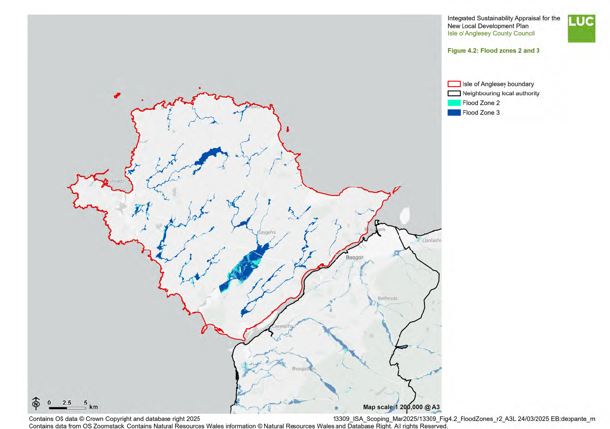
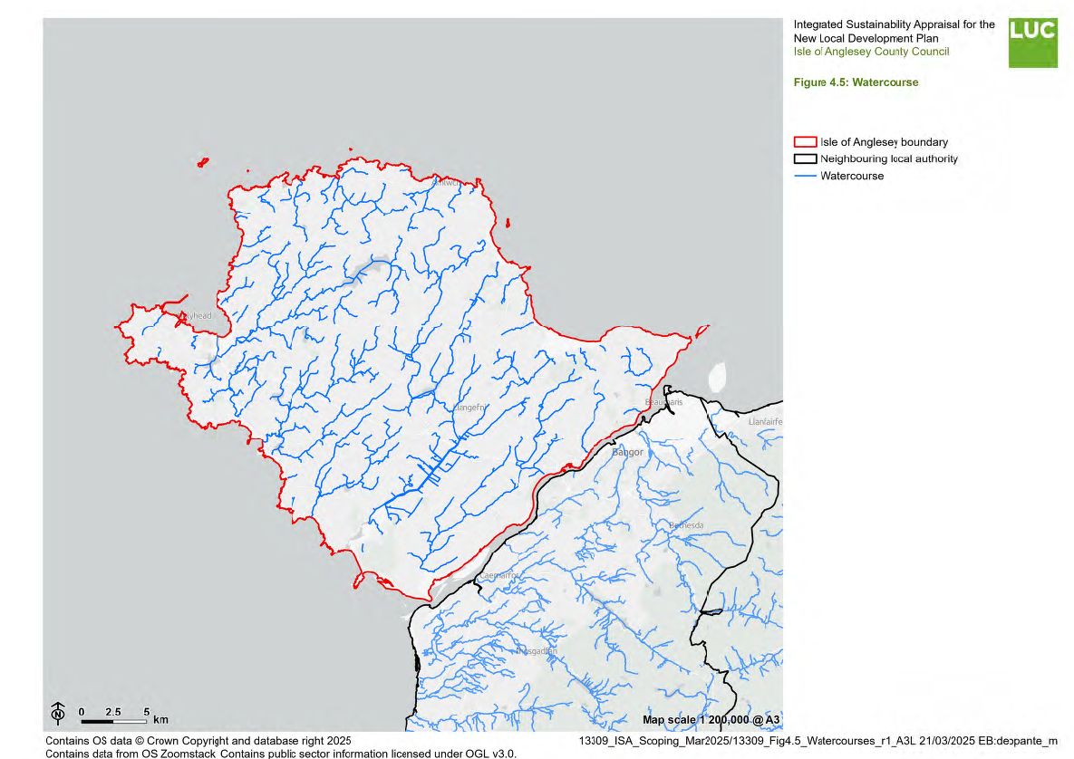
4.23 There are areas of Flood Zones 2 and 3, as well as areas of flood risk (ranging from high to low risk) associated with the sea, rivers, surface water, watercourses and reservoirs across Anglesey40, as shown in Figure 4.2.
4.24 The Stage 1 Strategic Flood Consequence Assessment (SFCA) produced for the Anglesey and Gwynedd Joint Local Development Plan41 reviews flood risk across Gwynedd and Anglesey. It maps flood risk across the area from a range of sources including rivers and sea, surface water, small watercourses and groundwater. It maps Flood Zones 2 and 3, as described above.
4.25 Most of the flooding on the island is attributed to surface water flooding, causing overload of the existing sewer systems which is particularly prevalent in Beaumaris, Holyhead, Dwyran and Llangefni. Llangefni and Dwyran are located on rivers and the flood risks here are from surface water run-off, sewer systems and also tidally influenced river flooding42.
4.26 On Anglesey flooding attributed directly to groundwater is extremely difficult to apportion as groundwater flooding usually occurs in combination with pluvial and fluvial flooding. As groundwater flooding occurs in low lying areas, basements of residential housing are usually impacted by this type of flooding43.
4.27 In comparison to other county councils, the Isle of Anglesey has a relatively low number of properties at risk of flooding. Specifically, there are 150 properties at low risk, 70 at medium risk and 86 at high risk, totalling 306 properties44.
4.28 The Isle of Anglesey has developed a Local Flood Risk Management Strategy45 with ten detailed objectives to reduce the consequences of flood risk. These include the use of local planning policy to ensure that no new flood risk is created and that where possible, opportunities to reduce flood risk are taken.
4.29 There are a number of flood defence structures on Anglesey. Notable schemes include:
- Holyhead Breakwater
- Dwyran Natural Flood Management Scheme
- Beaumaris Flood Reduction Scheme
- Llangefni Flood Defence Works
Biodiversity and geodiversity
4.30 Biodiversity is the term used to describe wildlife species, their habitats, and the relationships between ecosystems.
4.31 Anglesey has many species and a number of priority habitats. These include lowland and coastal heath, reedbeds, fens, broadleaved woodlands, ancient and species-rich hedgerows, ponds and flower-rich road verges. Added to these are some of the most extensive sand dunes in Wales46.
4.32 There are seven terrestrial Special Areas of Conservation (SACs) on Anglesey and one marine SAC. These are designated at the European level for specific habitats and species:
- Cemlyn Bay SAC
- Menai Strait Conwy Bay SAC
- Corsydd Mon SAC
- Llyn Dinam SAC
- Abermenai – Aberffraw dunes SAC
- Anglesey Coast saltmarsh SAC
- Glantraeth SAC
- Glannau Ynys Gybi SAC
4.33 There are four Special Protection Areas (SPAs) on Anglesey47:
- Glannau Ynys Gybi SPA
- North Anglesey Tern colonies SPA
- Ynys Seiriol SPA
- Liverpool Bay SPA
4.34 On Anglesey, the fens of Cors Erddreiniog, Cors Goch, Cors Bodeilio and Cors y Farl, along with similar areas at Cors Geirch and Cors Hirdre on the Llyn Peninsula, form the Anglesey and Lleyn Fens Ramsar site48.
4.35 North Anglesey Marine Protection Area (MPA) stretching from Trearddur round to Porth Eilian has been designated for the harbour porpoise. Porpoise and dolphins are often seen along this rocky stretch of coastline49.
4.36 There are 60 nationally designated Sites of Special Scientific Interest (SSSIs) on Anglesey. Some of these are also designated as SACs/SPAs/Ramsar sites.
4.37 There are six Local Nature Reserves (LNRs) on Anglesey:
- Coed Cyrnol LNR (Menai Bridge)
- Y Dingl LNR (Llangefni)
- Llandegfan LNR
- Llangoed LNR
- Llanddona LNR
- Wylfa Head LNR (Cemaes)
4.38 There are areas of Ancient Woodland scattered throughout Anglesey, including much of the Dingle Local Nature Reserve50 and Newborough National Nature Reserve and Forest51.
4.39 There are four RSPB reserves on Anglesey:
- South Stack
- Valley Lakes
- Malltraeth marsh
- The Skerries
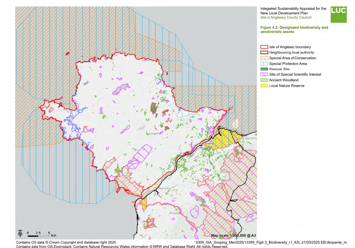
4.40 Figure 4.3 shows the distribution of designated biodiversity and geodiversity sites on the Isle of Anglesey.
Protected and priority species
4.41 The presence of protected species is a material planning consideration. Such species are detailed within the Wildlife and Countryside Act 1981, as amended by the Countryside and Rights of Way Act 200052.
4.42 Produced by Isle of Anglesey County Council in 2021, the 'Corporate Biodiversity Plan (2021-2022)53 focuses on a programme for the conservation and enhancement of Anglesey's biodiversity, listing the habitats and species of particular importance to the Isle.
4.43 A list of some locally important species to Anglesey is provided within the document. Certain notable species include:
- Red Squirrel
- Tern
- Porpoise
- Seal
- Chough
- Sand Lizard
- Otter
- Crested Newt
4.44 The Biodiversity Plan also acknowledges the island's wealth of rare plants, such as the county flower, the Spotted Rock Rose. Additionally, the South Stack Fleawort is only found at South Stack, and nowhere else in the world. Other plants that are in decline on the island include Chamomile, Pale Dog Violet and Lesser- Butterfly Orchid54.
Landscape
4.45 Anglesey is the largest of the Welsh islands, covering around 720km2, and is separated from the mainland by the Menai Strait. The main towns on the island are Llangefni, Holyhead, Amlwch, Benllech, Menai Bridge and Llanfair PG. Its topography is generally low-lying and undulating, punctuated by prominent rocky outcrops such as Holy Island, Mynydd Parys, Mynydd Bodafon, Mynydd y Garn and Mynydd Llwydiarth. The landform slopes from east to west, with several low-lying areas along the western coast, including Aberffraw, Malltraeth Marsh and Newborough Warren. This topographical pattern is mirrored in the north east-south west alignment of the island's watercourses55.
4.46 Despite its generally subdued character, Anglesey has a complex underlying geology shaped by geomorphological processes such as glaciation. The island contains some of the oldest rocks in Wales and Britain, which are evident in its topography. Tree cover is generally sparse, though ancient semi-natural woodlands can be found along the Menai Strait and extensive plantations exist around Mynydd Llwydiarth and Newborough Warren56.
4.47 Anglesey has a rich cultural history, with evidence of human activity spanning roughly 8,000 years. The island is home to over 200 Scheduled Ancient Monuments, ranging from Bronze Age burial chambers to medieval structures. More recent landscape features include the planned parklands of large estates such as Plas Newydd, major transport routes and industrial developments, including nuclear power and wind farms57.
4.48 The coastline of Anglesey was designated as an Area of Outstanding Natural Beauty (AONB), now referred to as a National Landscape, in 1967 in order to protect the aesthetic appeal and variety of the island's coastal landscape and habitats from inappropriate development. The National Landscape is 221km2 covering a third of the island, principally the coastal strip but also including Holyhead Mountain and Mynydd Bodafon58.
4.49 There are three sections of open, undeveloped coastline which have been designated as Heritage Coast stretching along 50 kms (31 miles) of the coastline59:
- North Anglesey 28.6kms (17 miles) – largely rugged cliffs with small bays, including the historically important port of Cemaes, the brickworks at Porth Wen and the copper exporting harbour at Porth Amlwch.
- Holyhead Mountain 12.9kms (8 miles) – including the iconic lighthouse on Ynys Lawd (South Stack) and cliffs extremely important for breeding seabirds, especially guillemot, razorbill and puffin.
- Aberffraw Bay 7.7kms (4.5 miles) – a sandy beach backed by a large area of sand dunes. The small town was once home to palace of the Kings of Gwynedd and a thriving port, now all silted up.
4.50 Anglesey lies within the North Wales and Caernarfon Bay national seascape units and includes nine regional units. These include60:
- Great Orme Head to Puffin Island
- Puffin Island to Point Lynas
- Point Lynas to Carmel Head
- Carmel Head to Holyhead Mountain North Stack
- Holyhead Mountain North Stack to Penrhyn Mawr
- Holy Island Straits
- Penrhyn Mawr to Pen y Parc/Malltraeth Bay
- Menai Strait 13
- Malltraeth Bay to Trefor
4.51 National Landscape Character Areas (NLCAs) are defined at a broad landscape scale throughout Wales and highlight what distinguishes one landscape from another, with reference to their regionally distinct natural, cultural and perceptual characteristics. They help to identify how the landscape is perceived and valued by people, providing integral information that can be used to inform plan-making that may impact the existing landscape.
4.52 Specific uses include:
- Planning policies and decisions
- Sensitivity and capacity studies
- Landscape and visual impact assessments
- Place making
- Forest and woodland strategies
4.53 The Isle of Anglesey is split between NLCA01: Anglesey Coast and NLCA02: Anglesey Interior61.
4.54 NLCA01: Anglesey Coast covers all coastal areas of the Isle of Anglesey, including Holy Island. The shape and form of the coastline are influenced by north east–south west geological faults and varying rock types. While much of Anglesey is low-lying, the northern half of the coastal area features higher hills, with Holyhead Mountain standing as the most prominent, its exposed, heath-covered slopes descending steeply into the sea. The prevailing winds create a notably more exposed south-westerly coastline, where well- developed dune systems and lagoons extend inland. Although much of the former estuary of the Afon Cefni has been reclaimed, the resulting coastal levels remain a defining feature of this landscape character area62.
4.55 NLCA02: Anglesey Interior forms the agricultural heart of the island, earning it the name Môn Mam Cymru - 'Anglesey, Mother of Wales.' Although primarily a gentle lowland landscape, the south west–north east geological fault lines influence variations in topography, creating occasional hills and rocky outcrops. The landscape also features several fens and extensive areas of drumlins, particularly in the north and west. Aside from hedgerows, cloddiau (hedge banks), occasional sheltered copses and areas of scrub, the landscape has an open, rolling and windswept character. It is the least wooded lowland landscape in Wales63.
4.56 The Anglesey Landscape Strategy64, updated in 2011, further identifies Landscape Character Areas (LCAs), which splits the Island between 18 LCAs. These character descriptions delve into more detail that those set out at National level.
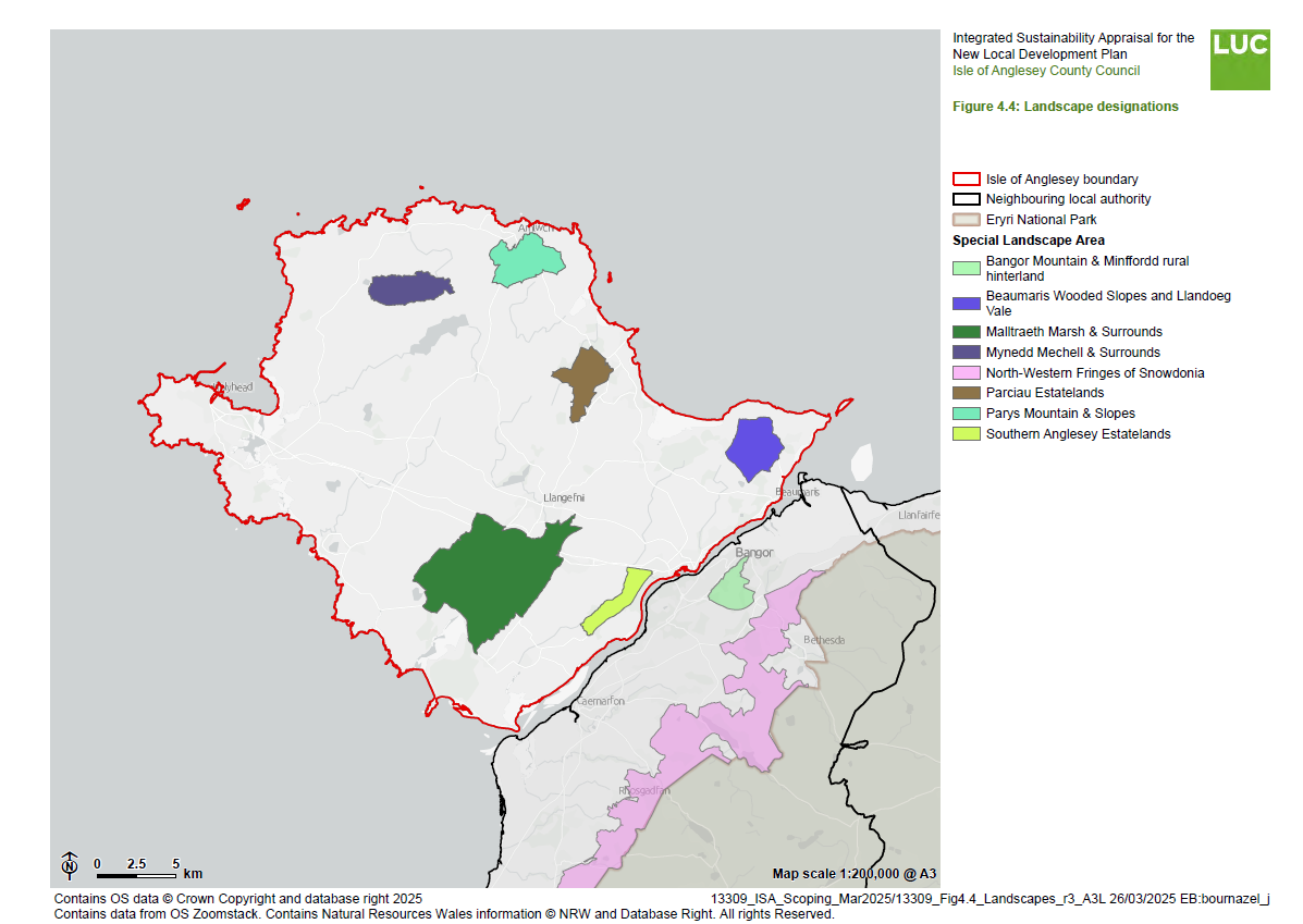
4.57 Local Development Plans include policies to protect Special Landscape Areas (SLAs). In 2012 Anglesey and Gwynedd Joint Planning Policy Unit (JPPU) commissioned LUC to undertake a thorough review of local landscape designations (Special Landscape Areas) in the two counties65. Table 24 of the Joint LDP specifies that there are six SLAs on Anglesey66. The location of the Special Landscape Areas is presented in Figure 4.4 and the following descriptions are outlined in LUC's 2012 review.
- Malltraeth Marsh and Surrounds
- A distinctive low-lying reclaimed marshland with a strong semi-natural, rural character, featuring regular fields, rock outcrops and woodland. It holds high landscape value (Outstanding for Historic Landscapes), offers views of Eryri and contributes to the setting of the Anglesey National Landscape.
- Parciau Estatelands
- A distinctive parkland and managed estate landscape with high tranquillity and a coherent character. It is lightly settled, rated 'Outstanding' for Historic Landscapes and forms the setting for the Anglesey National Landscape and A5025 coastal road.
- Parys Mountain and Slopes
- Parys Mountain is a unique and visually prominent feature in north Anglesey, with high cultural significance and a distinctive, colourful landscape shaped by geology and land use. It scores highly across LANDMAP aspects ('Outstanding' for Visual & Sensory) and forms a key part of the Anglesey National Landscape's setting, with strong intervisibility between the mountain, coast, and sea.
- Mynydd Mechell and Surrounds
- A distinctive, wild landscape with heathland, rough grazing, rock exposures and a hummocky topography, creating a sense of remoteness and tranquillity. It scores highly across LANDMAP aspects, forms part of the National Landscape's setting in the west and faces pressure from surrounding wind farms that contrast with its semi- natural, small-scale character.
- Beaumaris Wooded Slopes and Llangoed Vale
- A distinctive landscape of wooded slopes and rolling pastoral land, including Llanddona Commons Nature Reserve, offering relative tranquillity near Beaumaris, Llangoed and Llanddona. Rated 'Outstanding' for Cultural Landscapes, with strong time depth, rare broadleaved woodland, intervisibility with the Menai Straits and Eryri and under pressure from tourism-related development.
- Southern Anglesey Estatelands
- An area of strong estate character, linked to the Marquis of Anglesey's estate, forming the immediate backdrop to the Anglesey National Landscape and Menai Straits. Rated 'Outstanding' for Historic Landscapes and 'High' for Cultural Landscapes. It faces pressure from wind energy development.
4.58 SLAs are designated to protect areas of high landscape quality on the Isle of Anglesey. A regionally agreed upon methodology is applied when determining the designation of these landscapes, but the assessments are undertaken at a local level.
4.59 To protect the visual qualities of SLAs, development proposals in SLAs are required to conform to the highest possible design standards.
Water quality
4.60 The Water Framework Directive (WFD) provides a major overarching framework for river basin management and sets out a strategic approach to flood risk management planning. The purpose of the Directive is to establish a framework for the protection of inland surface waters (rivers and lakes), transitional waters (estuaries), coastal waters and groundwater. Groundwater is an important natural resource that supports river flows as well as ecological diversity in rivers, lakes and wetlands. It is also available for use, across the United Kingdom, for water supply by abstraction from boreholes, wells and springs.
4.61 There are no Source Protection Zones within the Isle of Anglesey.
4.62 The Isle of Anglesey falls within the Western Wales River Basin District (RBD). In line with the WFD, River Basin Management Plans (RBMPs) for each RBD are prepared for local governments involved in regulating, operating, influencing and undertaking projects in the RBD. According to the RBMP for the Western Wales RBD67, there are 566 water bodies within the river basin, of which 232 are in good ecological status, 256 are moderate, 48 are poor and three are bad. 496 are in good chemical status and 45 are failing in relation to their chemical status.
Water resources
4.63 The Anglesey Abstraction Management Strategy (2015)68 sets out how water resources are to be managed in Anglesey's river catchments. The Strategy identifies where water is likely to be available for abstraction in the main river catchments of Anglesey. It identifies that there is water availability in the Braint, Crigyll and Tan yr Rallt catchments and no water availability in the Alaw and Cefni catchments.
4.64 Since January 2018, most abstraction exemptions (if over 20 cubic meters per day) have been removed. This includes abstractions in areas that were previously exempt. Most abstractions now require a licence to continue legally abstracting water69.
4.65 Wastewater on Anglesey is presently handled by 29 wastewater treatment works (WwTW) that are owned and operated by Welsh Water (Dwr Cymru). These are split between small size WwTWs that serve a population under 2,000 and full sized WwTWs that serve a population greater than 2,000.
Open spaces
4.66 The most recent Open Space Assessment70 was undertaken in 2016. This study identified that aside from Llangefni, there is no settlement on Anglesey that fully meets all targets for open space provision. This is particularly the case in larger settlements such as Holyhead and Menai Bridge. Holyhead, with the highest population, faces the largest deficits, particularly in outdoor sports facilities (12.34 ha 'actual' against a target of 19.71 ha) and playing pitches (11.26 ha 'actual' against a target of 14.78 ha). However, it does have the most children's playing space (17.28 ha 'actual' against a 9.85 ha target).
4.67 A consistent pattern across Anglesey is the under provision of sports facilities and playing pitches. This is most notable in settlements such as Beaumaris and Rhosneigr. While rural settlements may have informal access to open countryside, the provision of designated recreational spaces remains an issue.
Air quality
4.68 The Environment Act 1995 introduced the requirement for local authorities to determine if statutory air quality objectives (AQOs) are likely to be exceeded. All local authorities now report to Welsh Government on an annual basis and have the obligation to declare Air Quality Management Areas (AQMAs) and develop action plans for improvement of air quality if objectives are likely to be exceeded.
4.69 The Well-being of Future Generations (Wales) Act 2015 requires that the Welsh Ministers must publish national indicators to be applied for the purpose of measuring progress towards the achievement of the well-being goals. National indicator number 4 is the level of nitrogen dioxide (NO2) pollution in the air. The National Indicator drives an alternative burden reduction approach aimed at achieving a reduction in the population weighted general level of NO2 a population is exposed to. An approach for the achievement of cleaner air in Wales is set out in the Clean Air Plan for Wales which includes a number of actions to enable collaborative approaches to reducing air pollution71.
4.70 There are currently no AQMAs on the Isle of Anglesey72.
Noise
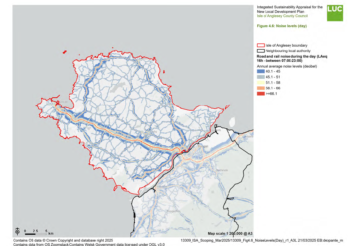
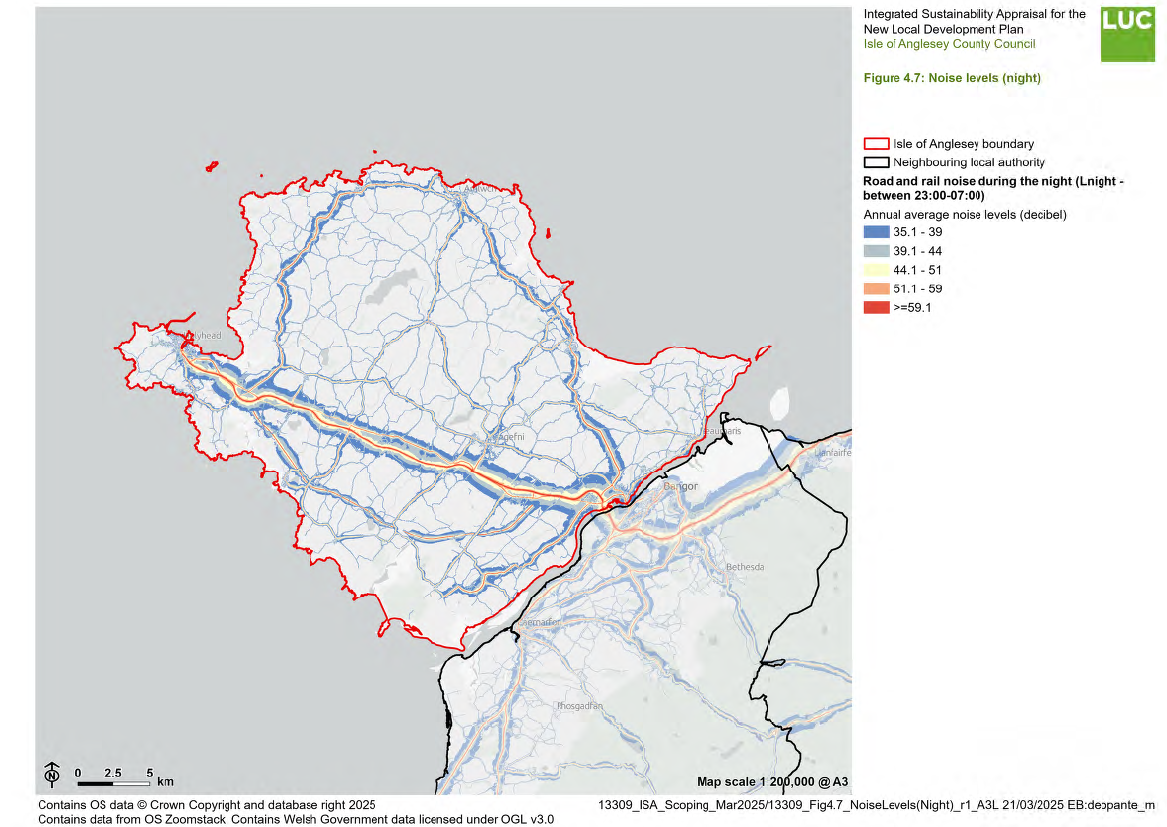
4.71 In total 20,445 noise complaints were received by local authorities in Wales in 2019/20, 65 complaints for every 10,000 population. Anglesey accounted for just 67 of these - the lowest out of all authorities73.
4.72 Figures 4.6 and 4.7 map noise levels across Anglesey during the day and at night. It can be seen that areas experiencing higher noise levels correspond with the main strategic roads. However, noise pollution is not limited to the road network and consideration should also be given to noise when considering development proposals near other noise sources. These may include, but are not limited to, industry and industrial estates, shopping centres/supermarkets and entertainment venues. Notably, noise can be amplified by the topography of an area.
4.73 Given the nature of many areas where noise pollution is prevalent (i.e. those affected by the strategic road network), the potential for these areas to also be adversely affected by air pollution also needs to be considered.
Soil quality
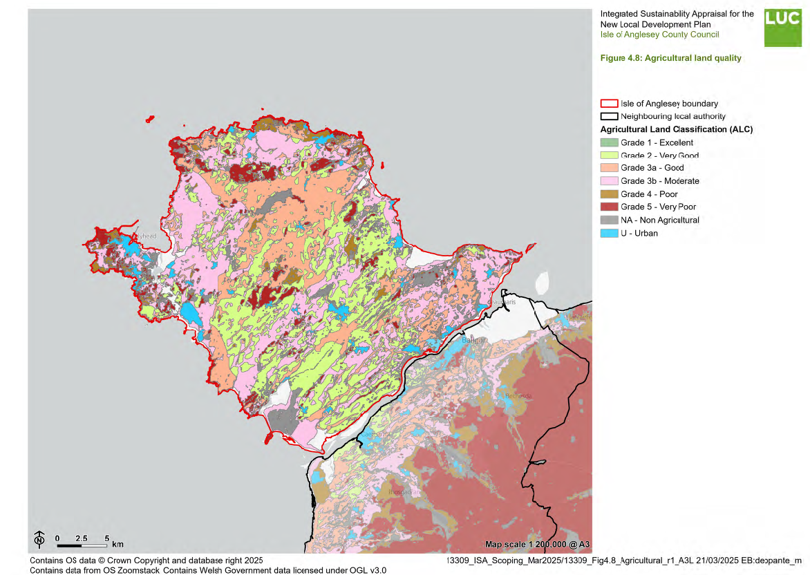
4.74 The Agricultural Land Classification (ALC) system provides a framework for classifying land according to the extent to which its physical or chemical characteristics impose long-term limitations on agricultural use. The principal factors influencing agricultural production are climate, site and soil. These factors, together with interactions between them, form the basis for classifying land into one of five grades, where Grade 1 describes land as excellent (land of high agricultural quality and potential) and Grade 5 describes land as very poor (land of low agricultural quality and potential). Land falling outside of these scores is deemed to be 'primarily in non- agricultural use', or 'land predominantly in urban use'74.
4.75 Planning policy defines grades 1 to 3a as the 'best and most versatile' agricultural land. This is about 10 - 15% of the land in Wales. Planning applications and local development plans should include survey evidence when they cover grade 1, 2 or 3a land75. There is no Grade 1 land on Anglesey, however a significant proportion of the Island is made up of Grade 2 and Grade 3a land, as shown in Figure 4.8.
Peatland
4.76 Peatland within Wales covers around 4.3% of the landmass, equating to circa 90,000 hectares. This acts as the largest terrestrial ecosystem store of carbon within Wales. However, owing to human activity it is now thought to be a Greenhouse Gas (GHG) emitter.
4.77 Policy areas relating to maintenance of peatland on Anglesey and Wales more widely include, but are not limited to:
- Mitigating and adapting to the effects of climate change.
- Mitigating and reducing flood risk.
- Protecting and enhancing biodiversity.
- Protecting the quality and quantity of water resources.
- Promoting the efficient use of land, soils, and minerals.
4.78 The Glastir Monitoring and Evaluation Programme (GMEP) provides data on Welsh peatlands. However, information available about the programme indicates that it has not been actively maintained since 2016.
4.79 The Welsh Peatlands Data Portal launched in April 2022 and contains information on the extent and depth of peatlands in Wales, including how much carbon they store and an estimate of carbon released into the atmosphere when in a poor condition. The portal indicates that Anglesey has some small pockets of peatland scattered over the Island. Some areas of peatland can be up to 120cm thick and have a carbon stock in the mid-range of 100.1 – 200.0 kg/m2 of carbon76.
Historic environment
4.80 The Register of Historic Landscapes in Wales (RHLW) is a non-statutory and advisory guide used to assist Local Authorities regarding how much weight to give to information in the historic register when determining planning applications. 'Penmon77' and 'Amlwch and Parys Mountain78' are included as two of these Historic Landscape Character Areas.
4.81 Penmon, located on the south eastern tip of Anglesey, is both a historically and archaeologically significant area with a rich heritage spanning from prehistory to modern day. It features dramatic limestone cliffs, medieval monastic sites and important defensive structures, including the Iron Age hillfort known as Bwrdd Arthur and the unfinished Beaumaris Castle, a 'pinnacle of medieval military architecture in Wales'. Religious and cultural heritage is evident in areas at Llanddona, Llangoed, Llaniestyn and Puffin Island, while industrial activity, including limestone quarrying, has shaped the landscape. The area played a strategic role in trade and governance, with Llanfaes and later Beaumaris serving as important settlements.
4.82 Parys Mountain, in northeast Anglesey, is a historically significant copper mining site that was the largest in the world during the 18th and 19th century, transforming the nearby town of Amlwch into an important trading hub. The vast opencast mines, known for their striking, barren 'moonscape' appearance, have evidence of copper extraction dating back to the Bronze Age. Mining operations peaked in the 1780s, employing thousands and supplying global markets, before declining in the 19th century due to overseas competition. The landscape retains industrial archaeological features, including dressing floors and kilns.
4.83 There are ten Historic Parks and Gardens on Anglesey79. These include:
- Bodowen
- Bodorgan
- Carreglwyd
- Cestyll
- Llanidan
- Plas Berw
- Plas Gwyn
- Plas Newydd
- Plas Rhianfa
- Ty Fry
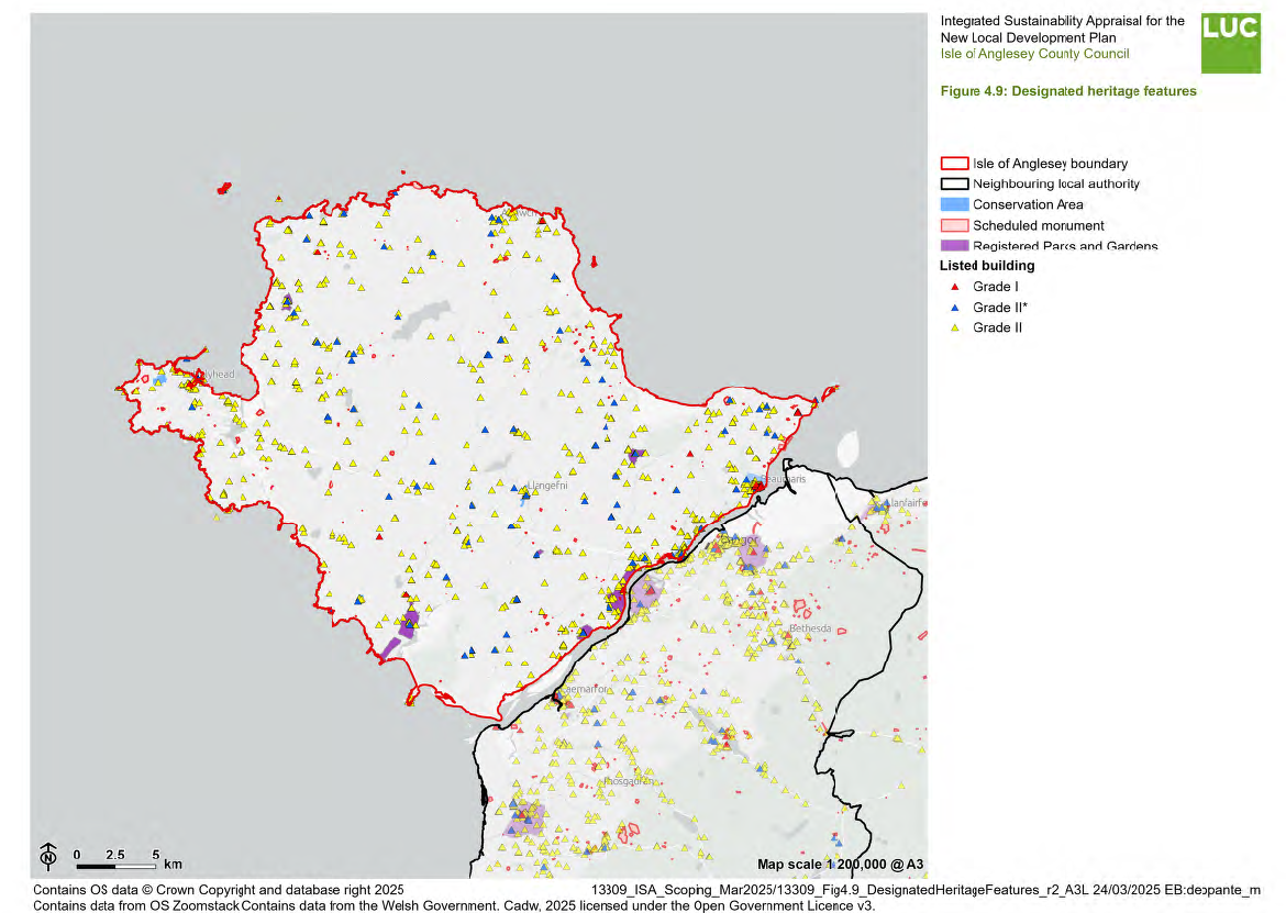
4.84 There are 1,125 listed buildings across Anglesey, with 39 being Grade I. 100 are Grade II* listed and 986 are Grade II80. They are distributed fairly evenly across Anglesey although there are concentrations around towns such as Holyhead, Beaumaris, and Amlwch, as might be expected. This pattern is illustrated in Figure 4.9, which shows designated heritage features across the Anglesey and the neighbouring local authority.
4.85 There are also 12 Conservation Areas on Anglesey, distributed across the Island81.
4.86 There are 432 Scheduled Monuments on Anglesey, including historic assets such as castles, hillforts and cairns.
4.87 Anglesey also contains numerous non-designated heritage assets which also contribute to the sense of place and value of the Island. These are detailed within the Historic Environment Record.
4.88 listed buildings at risk
Mineral resources
4.89 There are four working aggregate quarries on Anglesey, including Gwalchmai Quarry and Gwyndy Quarry.
4.90 In terms of economic need, there has been no metal mining on Anglesey since the 1800's. Parys Mountain near Amlwch is a major polymetallic mine which has been worked extensively over several centuries and its workings date back to the Bronze Age. More recently planning permission was granted to develop a modern mine at the site to include shaft sinking, construction of a processing plant and waste disposal. This activity is now suspended, although geological exploration and investigation continues to take place. In late 2024, the Environmental Impact Assessment Scoping Report for the Parys Mountain mine was approved by Anglesey County Council. The objective of the proposal is for the use of the site as a metal mine, carried out by underground methods. The existing price of metals does not favour production although it is difficult to predict how the global availability and price of metals will vary in the future82.
4.91 In terms of non-energy minerals, Minerals Planning Policy Wales83 stresses that policies and proposals in development plans should make clear where mineral extraction should or is most likely to take place. Anglesey contains a number of Minerals Safeguarding Areas, mainly for crushed rock. The role of Minerals Safeguarding Areas is to alert those proposing sites for future development to the presence of valuable mineral resources which they might not have otherwise considered.
4.92 Paragraph 5.10.17 of Planning Policy Wales (Edition 12)84 states that the safeguarding of primary coal resources is not a requirement but may be implemented at the discretion of the local planning authority. The decision about whether to continue the safeguarding of these minerals will be considered as part of the preparation of the LDP. Should Isle of Anglesey County Council choose to continue the safeguarding of coal resources, the PPW requires that the LDP include appropriate policies including those relating to pre-extraction policy.
Waste
4.93 There are currently two Household Waste Recycling Centres on Anglesey, as well as 13 recycling banks (SORT Centres) collecting a range of materials including paper, glass, cans and textiles85. The amount of waste that is recycled and energy recovered on Anglesey is shown in Table 4.686. In 2023/24, 64.7% of all waste on Anglesey was either reused, recycled or composted; up from 55.2% in 2012/1387.
Table 4.4: Annual waste collected for reuse/recycling/composting (tonnes) on Anglesey
|
Year |
Municipal waste (reused/ recycled) |
Municipal waste (composted) |
Total municipal waste (generated/ collected) |
|
2016/17 |
10,863 |
9,668 |
38,831 |
|
2017/18 |
10,988 |
10,100 |
37,562 |
|
2018/19 |
10,773 |
9,008 |
36,134 |
|
2019/20 |
10,895 |
9,363 |
36,360 |
|
2020/21 |
8,480 |
9,962 |
35,116 |
|
2021/22 |
10,187 |
8,084 |
35,603 |
|
2022/23 |
9,647 |
7,215 |
32,845 |
|
2023/24 |
9,469 |
7,591 |
33,901 |
4.94 There are two inert landfill sites on Anglesey (Rhuddlan Bach Quarry and Nant Newydd Quary). There are no hazardous waste landfills on the Isle of Anglesey88.
4.95 In 2022, it was announced that three former landfill sites on Anglesey and Gwynedd were to be transformed into a haven for biodiversity and conservation. Local Places for Nature funding from Welsh Government has since helped to restore 30 acres of land at Clegir Mawr (Gwalchmai, Anglesey), 74 acres at Ffridd Rasus (Harlech, Gwynedd) and 32 acres at Llwyn Isaf (Penygroes, Gwynedd) into rich and varied habitats for plants and wildlife89. Penhesgyn Landfill, a fourth site, remains an operational waste management site but the landfill part has been closed and been transformed into a Wild Landfill site. It covers an area of about 50 acres and was filled with up to 4 million tonnes of waste from the 1960s onwards90.
Social Baseline Information
Equalities
4.96 The Equality Act 2010 identifies nine 'protected characteristics' and seeks to protect people from discrimination on the basis of these characteristics. It presents three main duties: to eliminate discrimination, harassment, victimisation and other conduct that is prohibited under the Act; to advance equality of opportunity between persons who share relevant protected characteristics and persons who do not share it; and to foster good relations between persons who share a relevant protected characteristic and persons who do not share it. The nine protected characteristics identified through the Act are:
- age;
- disability;
- gender reassignment;
- marriage and civil partnership;
- pregnancy and maternity;
- race;
- religion or belief;
- sex; and
- sexual orientation.
4.97 The potential effects of the LDP in relation to groups covered by the nine 'protected characteristics' will be assessed separately in addition to the ISA, as described in Chapter 2. This work will comprise the EqIA which will be presented in an appendix to the ISA.
Age
4.98 According to the 2021 Census, 56.5% of people on Anglesey are aged between 16-6491. Between the last two censuses, the average (median) age of the Isle of Anglesey increased by three years, from 45 to 48 years of age. This is higher than the average (median) age in Wales as a whole (42 years).
4.99 The number of people aged 65 to 74 years rose by around 1,200 (an increase of 14.2%), while the number of residents aged between 35 and 49 years fell by around 2,300 (17.2% decrease)92. This indicates an ageing population, reflecting similar trends in Wales and the wider UK.
Disability
4.100 In the 2021 Census, 81.0% of Anglesey's population stated that they are not disabled under the Equality Act, while 19.1% stated that they were disabled under the Equality Act. Of those, 10.6% were 'limited a little' during day-to-day activities, whilst 8.5% were 'limited a lot93'. The proportion of people on Anglesey who are 'limited a lot' is lower than the Welsh average (10.0%)94.
Marriage and civil partnership
4.101 In the 2021 Census, 46.5% of Anglesey's population was married or in a registered civil partnership whilst 33.0% have never been married and have never registered a civil partnership. Marriage and civil partnership rates are higher than the average in Wales95.
4.102 These figures include same-sex marriages and opposite-sex civil partnerships in 2021, neither of which were legally recognised in England and Wales in 2011. Same-sex marriages have been legally recognised in England and Wales since 2014 and opposite-sex civil partnerships have been recognised since 201996.
Race
4.103 Data from the 2021 Census shows that 98.1% of Anglesey's population identify as white. This is higher than the Wales average of 93.8%97. On Anglesey, this is followed by 0.9% of people who identify as mixed or multiple ethnic groups, 0.6% of people who identify as Asian, Asian British or Asian Welsh and 0.2% who identify as Black, Black British, Black Welsh, Caribbean or African98.
Religion or belief
4.104 In the 2021 Census, 51.5% of Anglesey's residents described themselves as Christian, dropping from 65.1% in 2011. A further 40.7% of Isle of Anglesey residents reported having 'no religion', up from 25.5% in 2011. The rise of 15.2 percentage points was the largest increase of all broad religious groups in the Isle of Anglesey. Across Wales, the percentage of residents who described themselves as having "no religion" increased from 32.1% to 46.5%99 between 2011 and 2021.
4.105 There are many factors that can cause changes to the religious profile of an area, such as a changing age structure or residents relocating for work or education. Changes may also be caused by differences in the way individuals chose to self-identify between censuses. Religious affiliation is the religion with which someone connects or identifies, rather than their beliefs or religious practice100.
Sex
4.106 In the 2021 Census, Anglesey's population was 51.1% female and 48.9% male101.
Sexual orientation
4.107 In the 2021 Census, 89.99% of Anglesey's population identified as straight or heterosexual. 2.04% of residents identified as lesbian, gay, bisexual, or other (LGB+), whilst 7.97% did not answer102.
4.108 Also in the 2021 Census, 93.12% of Anglesey's population identified as the same sex registered at birth. 0.06% identified as trans women and 0.05% as trans men while 0.03% identified as non-binary. 6.59% of respondents did not answer.
4.109 No data were available relating to the remaining protected characteristics, specifically pregnancy and maternity.
Population
4.110 According to Census 2021 figures, between the last two censuses (held in 2011 and 2021), the population of the Isle of Anglesey fell by 1.3%, from just under 69,800 in 2011 to around 68,900 in 2021103.
4.111 This means the Isle of Anglesey was one of seven local authority areas in Wales to see its population decline. The population of Wales increased by 1.4%, from 3,063,000 to 3,107,000104.
Deprivation
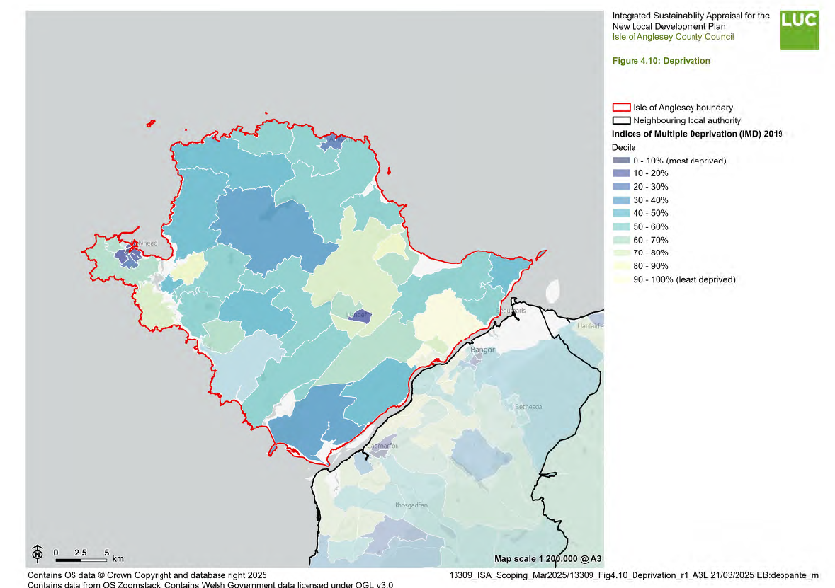
4.112 Wales is divided into 1,909 Lower-Layer Super Output Areas (LSOA) each having about 1,600 people. The Welsh Index of Multiple Deprivation (WIMD) ranks these LSOAs according to their relative deprivation levels across eight types of deprivation, and these are combined to produce an overall index. The most deprived LSOA is ranked 1, and the least deprived 1,909. One area has a higher deprivation rank than another if the proportion of people living there who are classed as deprived is higher.
4.113 39% of LSOAs on Anglesey are ranked as being within the 50% most deprived in Wales105. This is the sixth lowest percentage of any Welsh local authority. The spatial distribution of deprivation across the island is illustrated in Figure 4.10.
Crime and community safety
4.114 In relation to the community safety domain, WIMD data show that 41% of the LSOAs within Anglesey are within the 50% most deprived in Wales. This is the tenth lowest of the 22 Welsh local authority areas106.
4.115 At the end of 2023, there were 4,061 counts of total recorded crime on Anglesey. This is the fourth lowest count out of the 22 Welsh local authority areas. The highest recorded crime was theft, accounting for 38% of all crime committed on Anglesey107.
Education
4.116 In relation to the education domain, WIMD data show that 48% of the LSOAs within Anglesey are within the 50% most deprived in Wales. This is the ninth lowest of the 22 Welsh local authority areas108.
4.117 At the end of 2023, 90.4% of Anglesey's population was qualified to level 2 or above (equivalent to achieving GCSE grades 9, 8, 7, 6, 5, or 4 previously graded A*, A, B, or C). This is higher than the Wales average of 87.4%. Just 3.2% of Anglesey's population had no qualifications. This is lower than the Wales average (7.9%)109.
Health and wellbeing
4.118 Data from the 2021 Census shows that 81.9% of Anglesey's population reported themselves as being in very good, or good health. This is slightly higher than across Wales where 79.1% of people reported themselves as being in very good or good health. The proportions of people on Anglesey reporting themselves as being in bad or very bad health were 3.9% and 1.1% respectively. These figures are lower than the national figures for Wales of 5.1% and 1.6%, respectively110.
4.119 In relation to the health domain, WIMD data show that around 27% of the LSOAs within Anglesey are within the 50% most deprived in Wales. This is the fifth lowest percentage of any Welsh local authority111.
Life Expectancy
4.120 Life expectancy at birth for the period 2018-2020 on Anglesey was 79.3 years for males and 82.9 years for females, which is higher than the national figures of 78.3 years and 82.1 years respectively for Wales. From the period 2017- 2019 there has been a slight decrease in life expectancy for males and females within Anglesey and more widely within Wales112.
4.121 Within Anglesey for the period 2018-2020, there is a gap in healthy life expectancy at birth (comparing the least to most deprived fifth) of 7.8 years for males and 7.4 years for females. The gap at the national level for males and females is larger than that reported for Anglesey at 13.3 years and
16.9 years, respectively. Healthy life expectancy for the period 2018-2020 is higher on Anglesey than the national level for both males (64.2 years, compared to 61.5 years nationally) and females (63.6 years, compared to 62.4 years nationally)113.
Obesity
4.122 Being overweight or obese carries numerous health risks, including increased likelihood of type 2 diabetes, cancer, heart and liver disease, stroke and related mental health conditions. It is estimated this health issue places a cost of at least £5.1 billion on the NHS and tens of billions on the wider UK society every year114.
4.123 In 2021-2023 28% of adults on Anglesey were reported to be obese, and 58% overweight or obese. In comparison, the Welsh national average of obesity is 25% and 62% respectively. Additionally, it was found that only 16% of adults on Anglesey achieved their 5-a-day target of fruit and vegetables, compared to 29% across Wales. Furthermore, 47% of adults on Anglesey reported having undertaken no physical activity or exercise in the previous week. This compares to the Welsh national average of 31%115.
Perception of well-being
4.124 Anglesey residents reported having slightly higher levels of life satisfaction (7.5 out of 10) than the average for Wales (7.4) in the 2022/23 period. Average figures recorded relating to 'feeling the things done in life are worthwhile' on Anglesey were 7.9 out of 10, while 'happiness' was 7.3 out of 10. The figure is slightly higher for 'feeling the things done in life are worthwhile' than the average for Wales at 7.7 and the equal for 'happiness' at 7.3. Average levels of anxiety recorded for Anglesey were recorded at 3.5, higher than the average for Wales at 3.3116.
4.125 In 2022-23, the National Survey included questions to assess people's mental wellbeing. These were 14 statements designed to measure mental well-being known as the Warwick-Edinburgh Mental Well-being scale. Scores range from 14 to 70, with a higher score representing better mental well-being117.
4.126 The average mental wellbeing score in Wales was 48.2. Better mental wellbeing was found to be associated with each of the following factors:
- Being older
- Not being in material deprivation
- Being religious
- Having better general health
- Not having a long-term health condition or illness
- Being a Welsh speaker
- Participating in sport 3 or more times a week
Communities and housing
4.127 The Isle of Anglesey is a predominantly rural area, characterised by a mix of small towns, villages and dispersed rural communities. The island's settlement pattern is shaped by its coastal and inland geography, with key centres of population and economic activity including Holyhead, Llangefni and Amlwch (Urban Service Centres), Beaumaris, Menai Bridge, Benllech and Gaerwen (Local Service Centres)118.
4.128 The 2021 Census recorded 36,217 dwellings on Anglesey, an increase of 2.9% from the 2011 Census (35,200)119. Of these, 68.4% were owned (either outright or with a mortgage) 15.6% were social rented and a further 15.9% were privately rented or rent-free.
4.129 According to the Land Registry, house prices decreased by 2.2% between November 2023 (£245,440) and November 2024 (240,082) on Anglesey120. For comparison, house prices in Wales increased to an average of £204,197, which represents a 1.0% increase over the year ended December 2024121. As of November 2024, average house prices on Anglesey are amongst the top ten most expensive local authorities in Wales, ranking sixth. The top five are Monmouthshire (£346,479), Vale of Glamorgan (£292,490), Cardiff (£272,692), Ceredigion (£242,025) and Powys (241,821).
4.130 The Joint LDP set a target of delivering 7,184 new housing units over the Plan period. However, a comparison of housing completions against this target in the years leading up to the latest monitoring report122 indicates that the number of new homes built has fallen below the expected level. This is shown below in Table 4.5.
Table 4.5: Number of units delivered in the JLDP area versus actual number
|
Year |
Target |
Actual number |
|
2016/17 |
376 |
402 |
|
2017/18 |
505 |
462 |
|
2018/19 |
617 |
548 |
4.131 The most recent Local Housing Market Assessment (LHMA) undertaken in 2025123 identified a shortfall of 398 affordable units per annum. The LHMA identifies a net annual gross need of 167 affordable housing units over the first five years to 2028, after accounting for planned supply and turnover of existing housing stock. This includes 73 social rent, 31 intermediate rent, and 63 low-cost homeownership units. There is a net need for all sizes of affordable housing, although the greatest demand is for one-bedroom social rent units, requiring 65 per year.
4.132 Plans to increase the Council's housing stock from 4,000 to over 5,000 homes are included in the Housing Revenue Account Business Plan 2023-2053, which was approved by Executive members in early 2023124.
4.133 It will see Anglesey's Housing Services build 45 new Council houses every year for the next 30 years to help meet the significant demand for social housing. One of the largest projects includes the redevelopment of the former Ysgol Thomas Ellis site in Holyhead to include total of 45 new social homes. Other Council housing projects are planned for Amlwch (40 homes) and Niwbwrch (14 homes) as well as several other significant projects across the island125.
4.134 In 2023, the average household size on Anglesey was 2.20, which is roughly equivalent to Wales as a whole (2.26)126. Anglesey's household size has decreased year on year over the past decade, where in 2012 the average size was 2.25.
4.135 In 2021, 47.4% of households on Anglesey were detached (whole house or bungalow) housing, 22.9% were semi-detached, 22.1% were terraced, 7.0% were flats, maisonettes or apartments and 0.6% were caravans or other mobile or temporary structures.
4.136 as per the 2021 Census, 0.1% of people on the Isle of Anglesey identified as Gypsy or Irish Traveller (WGoIT) ethnicity127. This equates to around 69 people. The Gypsy and Traveller Accommodation Assessment (GTAA) 2022128 identifies that in 2011, most of the Gypsy or Irish Traveller population lived in bricks and mortar accommodation.
4.137 The latest caravan county data (January 2021) reports a total of one caravan on an unauthorised site on Anglesey. There is one tolerated caravan on public land on Anglesey. The GTAA further assesses the future accommodation needs for residential pitches. For Anglesey, the assessment identifies that by 2036, a total of 11 pitches will be required, meaning only two more pitches will be needed between 2025 and 2036.
Welsh language
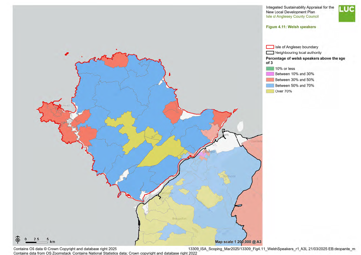
4.138 In 1921, there were a little under a million people aged three years or older able to speak Welsh in Wales (922,100 people). This decreased over the last century, reaching a low of around 503,500 in 1981. The number of people able to speak Welsh increased between 1981 and 2001 but has since decreased129.
4.139 At the time of the 2021 Census, an estimated 538,300 usual residents in Wales aged three years or older were reported as being able to speak Welsh. This is around 17.8% of the population in Wales, the lowest proportion ever recorded in a census. This is a decrease of around 23,700 people since Census 2011, or a decrease of 1.2 percentage points. The highest percentages of people aged three years or older able to speak Welsh are in north-west Wales (Gwynedd and Anglesey)130.
4.140 At the time of the 2021 Census, 58.1% of Anglesey's population could speak, read or write Welsh and 11.1% could understand spoken Welsh only. 30.7% of people had no skills in Welsh. The number of people who can speak, read or write Welsh has decreased by 0.7% between 2011 and 2021131.
4.141 Anglesey's Welsh in Education Strategic Plan 2022 – 2032 (WESP)132 sets out the approach to improve the use and access to the Welsh language. This includes increasing the use of Welsh amongst school children, transferring Welsh language skills from one stage of statutory education to another, creating more opportunities for learners to use Welsh and increasing the number of teaching staff able to teach Wesh, amongst other objectives.
4.142 Figure 4.11 maps the proportion of Welsh speakers across Anglesey.
Education
4.143 The authority has one of the smallest school populations numbering under 10,000 students. Isle of Anglesey County Council has responsibility for 49 schools. There are 43 primary schools with an average size of 129 pupils, ranging from Ysgol Gymuned Garreglefn with just over 20 pupils, to Ysgol Cybi in Holyhead with over 425 pupils. There are five secondary schools all of which have sixth forms133.
4.144 Almost all of Anglesey's primary schools are Welsh medium – one is dual language and one is English medium. Four of the secondary schools are Bilingual and one is English medium.
Economic Baseline Information
Economy and employment
4.145 In 2019, the main employment sector for residents of Anglesey was 'Wholesale, retail, transport, hotels and food' (9,200 people), followed by 'Public administration, defence, education and health' (6,300 people) and production (3,000)134.
4.146 Tourism and recreation are vital to Anglesey's economy, with the island attracting 1.71 million visitors annually, generating £304 million per year135. The tourism sector employs approximately 20% of the island's population – the highest proportion of any local authority in Wales. This highlights the sector's role as a critical component of Anglesey's economy136.
4.147 The growth in the tourism sector on Anglesey far outstrips that of the rest of Wales with a 64% increase in revenue between 2006 and 2017, representing growth of 7% (4% higher than the national average). Although Anglesey predominately attracts tourists from the North West of England, Holyhead has also become a destination of choice for cruise ship operators. 2018 saw 43 cruise ships visit with approximately 32,700 passengers potentially disembarking. With an average spend of between £80 and £100 per head, passengers contribute significantly to the island's economy137.
4.148 In 2021, 31.0% of Anglesey's population worked less than 10km from home and 30.5% worked over 10km from home and 15.9% worked mainly at an offshore installation, in no fixed place, or outside the UK. 22.5% of Anglesey's residents worked mainly from home138 – this percentage is likely to have increased significantly as a result of the Coronavirus pandemic and it is not known whether the proportion of home workers will have remined as high as it was in 2021.
4.149 The average gross weekly earnings on Anglesey in 2024 was £704.90. This is higher than the Welsh average (£674.50)139.
4.150 In the year ending 30 September 2024, 17.7% of Anglesey's residents were classed as economically inactive. This is lower than the Welsh average (20.8%) and in line with the UK average (17.7%)140.
4.151 The Employment Land Review (2012) leads to the requirement to safeguard 642.9 ha of existing employment land in the Plan area (including Gwynedd) and to allocate 55.1 ha of new sites in the Plan area, plus an additional 144.1 ha in reserve on the island141.
Transport infrastructure
4.152 The geography of Anglesey influences its transport network, with key routes stemming from major settlements and linking to the mainland via the A55, the island's primary strategic route. The A55, also known as the North Wales Expressway, provides a vital connection to North Wales, the M56 and the wider UK road network, supporting local travel and freight movement. Britannia Bridge, which carries the A55 road and the North Wales Coast railway line across the Menai Strait, regularly experiences closures, traffic restrictions, and reduced speed limits, due to extreme weather conditions. This affects local traffic and traffic travelling to/from the Port of Holyhead. There are, however, plans to build a third crossing to the east of Britannia Bridge, with intentions of starting construction in 2027142.
4.153 Other key roads, such as the A5025 and A4080, connect rural communities but are often constrained by their rural nature, limited capacity and seasonal congestion, particularly in popular tourist areas. While external connectivity is strong, internal transport links can be more challenging, with some routes passing through narrow village centres and coastal areas that are less suited to heavy traffic.
4.154 Public transport on Anglesey is primarily provided by bus and rail services, facilitating connectivity within the island and to the mainland. The bus network serves key settlements, including Holyhead, Llangefni, Amlwch and Beaumaris, with routes extending to smaller rural communities. However, services can be infrequent in more remote areas, limiting accessibility for those without private transport. The main railway line serving Anglesey crosses the Menai Straits on the re-modelled Britannia Bridge, before arriving at the first station, Llanfairpwll. After this station, the route is striking in that it avoids the larger towns and villages, taking a curving route along the western side of the island before terminating at Holyhead. This route was borne out of a need to create a fast link between London and Dublin, and the potential revenue from local passengers was therefore a secondary consideration. Aside from Holyhead and Llanfairpwll, all railways on Anglesey are request stops, whereby trains only halt if signalled143. While public transport links are vital for residents and visitors, challenges remain in terms of service frequency, rural coverage, and integration between bus and rail networks, particularly for those reliant on public transport for daily commuting and essential services.
Traffic flows, travel to work/commuting patterns
4.155 At the time of the 2021 Census, 26,002 people were recorded as working on the Isle of Anglesey. Of these, 11,007 either worked from home or had no fixed place of work, while 11,723 commuted within Anglesey itself144.
4.156 There is a notable inflow and outflow of workers between Anglesey and mainland North Wales. The largest inbound movement came from Gwynedd (2,341 people), followed by Conwy (349 people) and Denbighshire (60 people). Conversely, outward commuting from Anglesey was significantly higher, with 4,595 residents travelling to work in Gwynedd, followed by 562 to Conwy and 127 to Denbighshire.
4.157 Commuting patterns show that Llangefni had the largest workday population of 2,940 people commuting in from other areas. Additionally, 805 people travelled within Llangefni for work, while 974 people either worked from home or had no fixed workplace. The largest inbound flows to Llangefni came from Newborough (355 people), Holyhead (316 people), and Amlwch and Llannerch-y-medd (309 people). In contrast, the largest outward flows from Llangefni were to Bangor South (222 people), Newborough (161 people) and Bodedern and Rhosneigr (88 people).
4.158 According to the 2021 Census, the primary method used to travel to work on Anglesey is by driving a car or van, accounting for 61.3% of the working population. An additional 4.6% travel as a passenger in a car or van. The second most common mode of transport (not including the 22.5% of those who work from home) is on foot, accounting for 6.8% of the working population. Just 1.6% travel to work on using a bus, minibus or coach and 0.4% travel to work using the train145.
Difficulties encountered
4.159 It is a requirement of the SEA Regulations that consideration is given to any data limitations or other difficulties that are encountered during the SA process. Difficulties and limitations that arose during the preparation of the ISA Scoping Report are outlined below:
- Anglesey has a high proportion of second homes and short-term holiday lets, but data on their exact impact on housing availability and affordability is often incomplete and inaccessible. The presence of second homes and short-term holiday lets may also skew statistics on housing availability and economic data.
- While general transport infrastructure data (e.g. roads and rail lines) is available, detailed passenger usage statistics (e.g. for rural bus services) is limited. There is also a lack of commissioned research into local travel and transport statistics. For example, the most applicable Transport Plan is regional and applies to the entirety of North Wales rather than Anglesey146.
- Reliance on outdated data sources, including The Employment Land Review (2012) and Annual Monitoring Reports, which may not reflect current economic and development trends.
Footnote References
21 ASC (2016) UK Climate Change Risk Assessment 2017 Evidence Report –
Summary for Wales. Adaptation Sub-Committee of the Committee on Climate
Change, London.
22 Met Office (2018) Climate change projections over land [online] Available at:
https://www.metoffice.gov.uk/research/approach/collaboration/ukcp/summaries/c
limate-change-projections-over-land
23 Isle of Anglesey Council (no date) Climate change. Available at:
https://www.anglesey.gov.wales/en/Council/Climate-change.aspx
24 Department for Energy Security & Net Zero (2024) UK local authority and
regional carbon dioxide emissions national statistics: 2005 to 2022. Available at:
https://assets.publishing.service.gov.uk/media/667ad4f0aec8650b1008ffc6/local
-authority-ghg-one-page-summary-2022.pdf
25 Department for Energy Security & Net Zero (2024) UK local authority and
regional carbon dioxide emissions national statistics: 2005 to 2022. Available at:
https://assets.publishing.service.gov.uk/media/667ad5b45b0d63b556a4b305/20
05-22-uk-local-authority-ghg-emissions.xlsx
26 Ibid.
27 Welsh Government (2025) Energy Generation in Wales: 2023. Available at:
https://www.gov.wales/sites/default/files/publications/2025-02/energygeneration-
in-wales-2023.pdf
29 Ibid.
29 Ibid.
30 Department for Energy Security and Net Zero (2024) Renewable electricity by
local authority 2014 – 2023. Available at:
https://assets.publishing.service.gov.uk/media/67226ea53ce5634f5f6ef5a1/Ren
ewable_electricity_by_local_authority_2014_-
_2023.xlsx#:~:text=Cover%20sheet&text=Revisions%20for%20previous%20yea
rs%20have,in%202019%2C%202021%20and%202022.&text=The%20data%20
tables%20and%20accompanying,see%20LINK%20or%20contact%20EMAIL.
31 Welsh Government (2022) Energy Generation in Wales. Available at:
https://www.gov.wales/sites/default/files/publications/2023-11/energygeneration-
in-wales-2022.pdf
32 Ynni ar Energy on Ynys Mon (no date) Energy Island: Ynys Mon’s unique
position. Available at: https://ynniarynysmon.cymru/energy-island
33 Ibid.
34 ONS (2024) 2021 Census: Car or van availability by household composition.
Available at: https://www.ons.gov.uk/datasets/RM008/editions/2021/versions/3
35 ONS (2021) 2021 Census: Census Maps. Available at:
https://www.ons.gov.uk/census/maps/?lad=W06000001
36 Department for Transport (2025) Electric vehicle charging devices by local
authority. Available at: https://maps.dft.gov.uk/ev-charging-map/index.html
37 Isle of Anglesey County Council (2024) Towards Net Zero Plan 2023 – 2024
Annual Report. Available at: https://www.anglesey.gov.wales/documents/Docsen/
Council/Climate-change/Annual-report/Towards-Net-Zero-Plan-Annualreport-
2023-to-2024.pdf
38 Welsh Parliament – Senedd Research (2025) After the flood: reflecting on
Storms Bert and Darragh. Available at: https://research.senedd.wales/researcharticles/
after-the-flood-reflecting-on-storms-bert-and-darragh/
39 Natural Resources Wales (2016) Ynys Mon Management Catchment
Summary. Available at:
https://naturalresources.wales/media/679396/2016_updated_ynys_mon_catchm
ent_summary_nrw.pdf
40 Natural Resources Wales (2022) Flood and Coastal Erosion Risk Maps.
Available at: https://flood-risk-maps.naturalresources.wales/?locale=en
41 Gwynedd and Anglesey Joint Unit (2016) Topic Paper 8A: Strategic Flood
Consequence Assessment (Stage 1). Available at:
https://www.gwynedd.llyw.cymru/en/Council/Documents---Council/Strategiesand-
policies/Environment-and-planning/Planning-policy/Supportingdocuments/
Topic-Paper-8A---SFCA-(PT.015).pdf
42 The Isle of Anglesey County Council (2013) Anglesey Local Flood Risk
Management Strategy. Available at:
https://www.anglesey.gov.wales/documents/Docsen/
Highways/Flooding/Anglesey-Local-Flood-Risk-Management-Strategy.pdf
43 Ibid.
44 Welsh Government (2024) Properties at Risk of Flooding 2024. Available at:
https://statswales.gov.wales/Catalogue/Environment-and-
Countryside/Flooding/propertiesatriskofflooding2024
45 The Isle of Anglesey County Council (2013) Anglesey Local Flood Risk
Management Strategy. Available at: https://www.anglesey.gov.wales/documents/Docsen/
Highways/Flooding/Anglesey-Local-Flood-Risk-Management-Strategy.pdf
46 Isle of Anglesey County Council (2021) Corporate Biodiversity Plan 2021 –
2022. Available at: https://www.anglesey.gov.wales/documents/Docsen/
Biodiversity/Biodiversity-Plan.pdf
47 Ibid.
48 Ibid.
49 Ibid.
50 Visit Angelsey (no date) Dingle Local Nature Reserve. Available at:
https://www.visitanglesey.co.uk/en-gb/explore/wildlife/dingle-local-naturereserve#:~:
text=Another%20name%20for%20the%20Dingle,literally%20means
%20steep%20wooded%20valley.
51 Natural Resources Wales (no date) Newborough National Nature Reserve
and Forest, Anglesey. Available at: https://naturalresources.wales/daysout/
places-to-visit/north-west-wales/newborough/?lang=en
52 UK Government (2000) Countryside and Rights of Way Act 2000.
53 Isle of Anglesey County Council (2021) Corporate Biodiversity Plan 2021 –
2022. Available at: https://www.anglesey.gov.wales/documents/Docsen/
Biodiversity/Biodiversity-Plan.pdf
54 Ibid.
55 The Isle of Anglesey County Council (2011) Anglesey Landscape Strategy.
Available at: https://www.gwynedd.llyw.cymru/en/Council/Documents---
Council/Strategies-and-policies/Environment-and-planning/Planningpolicy/
Supporting-documents/Anglesey-Landscape-Strategy-Update-2011.pdf
56 Ibid.
57 Ibid.
58 Geomôn Global Geopark (no date) Biodiversity, Conservation and protected
areas. Available at: https://www.geomon.co.uk/geomon-unesco-globalgeopark/
biodiversity-conservation-and-protected-areas/
59 Ibid.
60 Ibid.
61 Natural Resources Wales (2023) NLCA Map. Available at: https://nrwcmsv13-
a3hwekacajb3frbw.a02.azurefd.net/682542/nlca-map-andnames.
pdf?rmode=pad&v=1d32570108590b0
62 Natural Resources Wales (2014) Anglesey Coast. Available at:
https://nrwcmsv13-a3hwekacajb3frbw.a02.azurefd.net/682546/nlca01-angleseycoast-
description.pdf?rmode=pad&v=1d35c894417ed10
63 Natural Resources Wales (2014) Central Anglesey. Available at:
https://nrwcmsv13-a3hwekacajb3frbw.a02.azurefd.net/682548/nlca02-centralanglesey-
description.pdf?rmode=pad&v=1d35c8bc5b10a80
64 The Isle of Anglesey County Council (2011) Anglesey Landscape Strategy.
Available at: https://www.gwynedd.llyw.cymru/en/Council/Documents---
Council/Strategies-and-policies/Environment-and-planning/Planningpolicy/
Supporting-documents/Anglesey-Landscape-Strategy-Update-2011.pdf
65 LUC (2012) Review of Special Landscape Areas in Gwynedd and Anglesey.
Available at: https://www.gwynedd.llyw.cymru/en/Council/Documents---
Council/Strategies-and-policies/Environment-and-planning/Planningpolicy/Supporting-documents/Review-of-SLAs-in-Gwynedd-and-Anglesey-
(DC.008).pdf
66 Anglesey and Gwynedd Joint Planning Policy Unit (2016) Anglesey and
Gwynedd Joint Local Development Plan 2011 - 2026. Available at:
https://www.gwynedd.llyw.cymru/en/Council/Documents---Council/Strategieswithand-policies/Environment-and-planning/Planning-policy/Anglesey-and-Gwynedd-Joint-Local-Development-Plan-Written-Statement.pdf
67 Natural Resources Wales (2022) Western Wales River Basin Management
Plan 2021 – 2027 Summary. Available at:
https://naturalresources.wales/media/695227/western-wales-rbmp-2021_2027-
summary.pdf
68 Natural Resources Wales (2015) Anglesey Catchment Abstraction
Management Strategy. Available at:
https://cdn.cyfoethnaturiol.cymru/674754/anglesy_cams_2015_english.pdf?mod
e=pad&rnd=131596369485030000
69 Natural Resources Wales (2024) Water available in our catchments. Available
at: https://naturalresources.wales/about-us/what-we-do/our-roles-andresponsibilities/
water/water-available-in-ourcatchments/?
lang=en#:~:text=From%201%20January%202018%2C%20most,b
e%20downloaded%20from%20Gov.uk.
70 Anglesey and Gwynedd Joint Local Development Plan (2016) Topic Paper 14:
Open Space Assessment. Available at: https://www.gwynedd.llyw.cymru/en/Council/Documents---Council/Strategiesand-
policies/Environment-and-planning/Planning-policy/Supportingdocuments/
Topic-Paper-14A---Open-Space-Assessment-(PT.025).pdf
71 Welsh Government (2020) The Clean Air Plan for Wales
72 Air Quality in Wales (2025) Air Quality Management Areas. Available at:
https://www.airquality.gov.wales/laqm/air-quality-management-areas
73 Chartered Institute of Environmental Health (2021) CIEH Noise Survey
2019/20 Report on findings – Wales. Available at:
https://www.cieh.org/media/6318/wales-noise-survey-2019-2020.pdf
74 Welsh Government (2019) Agricultural land classification: predictive map.
Available at: https://www.gov.wales/agricultural-land-classification-predictivemap#:~:
text=grade%201%3A%20excellent%20quality%20agricultural,3b%3A%
20moderate%20quality%20agricultural%20land
75 Welsh Government (2019) Agricultural land classification: predictive map.
Available at: https://www.gov.wales/agricultural-land-classification-predictivemap#:~:
text=grade%201%3A%20excellent%20quality%20agricultural,3b%3A%
20moderate%20quality%20agricultural%20land
76 Natural Resources Wales (2022) Welsh Peatlands Data Portal. Available at:
https://experience.arcgis.com/experience/d18ef8c74ecc4dc4a0cbf71ab6935ba0
77 Welsh Government (2001) Full Reports of Registered Historic Landscape.
Penmon. Available at: https://cadwpublicapi.
azurewebsites.net/reports/historiclandscape/FullReport?lang=en&id=HLW%
20(Gw)%2015
78 Welsh Government (2001) Full Reports of Registered Historic Landscape.
Amlwch and Parys Mountain. Available at: https://cadwpublicapi.
azurewebsites.net/reports/historiclandscape/FullReport?lang=en&id=HLW%
20(Gw)%201
79 Cadw (2025) Search Cadw records. Available at:
https://cadw.gov.wales/advice-support/cof-cymru/search-cadw-records
80 Ibid
81 Isle of Anglesey County Council (no date) Where are the conservation areas?
Available at: https://www.anglesey.gov.wales/en/Residents/Planning-buildingcontrol-
and-conservation/Built-and-natural-environment/Conservationareas/
Where-are-the-conservation-areas.aspx
82 Gwynedd and Anglesey Joint Unit (2016) Topic Paper 11A: Minerals.
Available at: https://www.gwynedd.llyw.cymru/en/Council/Documents---
Council/Strategies-and-policies/Environment-and-planning/Planningpolicy/
Supporting-documents/Topic-Paper-11A---Minerals-(PT.022).pdf
83 Welsh Government (no date) Planning policy and guidance: minerals and
mining. Available at: https://www.gov.wales/planning-policy-and-guidanceminerals-
and-mining
84 Welsh Government (2024) Planning Policy Wales (Edition 12). Available at:
https://www.gov.wales/sites/default/files/publications/2024-07/planning-policywales-
edition-12.pdf
85 Isle of Anglesey County Council (no date) Recycling centres and recycling
banks. Available at: https://www.anglesey.gov.wales/en/Residents/Bins-andrecycling/
Recycling-centres-and-recycling-banks/Section.aspx
86 StatsWales (2025) Annual waste collected for reuse/recycling/composting
(tonnes) by material and source. Available at:
https://statswales.gov.wales/Catalogue/Environment-and-Countryside/Waste-
Management/Local-Authority-Municipal-
Waste/annualwastereusedrecycledcomposted-by-material-source-year
87 StatsWales (2025) Annual reuse/recycling/composting rates by local authority.
Available at: https://statswales.gov.wales/Catalogue/Environment-and-Countryside/Waste-Management/Local-Authority-Municipal-
Waste/annualreuserecyclingcompostingrates-by-localauthority-year
88 Wylfa Newydd Project (2018) Local and regional waste management
facilities. Available at: https://infrastructure.planninginspectorate.gov.uk/wpcontent/
ipc/uploads/projects/EN010007/EN010007-001427-
6.3.30%20App%20C6-1-
Local%20and%20regional%20waste%20management%20facilities%20(Rev%2
01.0).pdf
89 Isle of Anglesey County Council (2022) Landfill sites to become haven for
wildlife. Available at:
https://www.anglesey.gov.wales/en/newsroom/news/landfill-sites-to-becomehaven-
for-wildlife
90 Wild Landfill (2025) Our Sites. Available at: https://www.wildlandfill.com/sites
91 ONS (2023) Cenus maps. Available at:
https://www.ons.gov.uk/census/maps/choropleth?lad=W06000001
92 ONS (2023) How life has changed on the Isle of Anglesey: Census 2021.
Available at:
https://www.ons.gov.uk/visualisations/censusareachanges/W06000001/
93 ONS (2023) Census maps. Available at:
https://www.ons.gov.uk/census/maps/choropleth?lad=W06000001
94 ONS (2023) How life has changed on the Isle of Anglesey: Census 2021.
Available at:
https://www.ons.gov.uk/visualisations/censusareachanges/W06000001/
95 ONS (2023) How life has changed on the Isle of Anglesey: Census 2021.
Available at:
https://www.ons.gov.uk/visualisations/censusareachanges/W06000001/
96 Ibid.
97 Welsh Government (2022) Ethnic group, national identity, language and
religion in Wales (Census 2021). Available at: https://www.gov.wales/ethnicgroup-
national-identity-language-and-religion-wales-census-2021-
html#:~:text=On%20Census%20Day%2C%2021%20March,Irish%20or%20Britis
h%E2%80%9D%20in%202021.
98 ONS (2023) Census maps. Available at:
https://www.ons.gov.uk/census/maps/choropleth?lad=W06000001
99 Ibid.
100 Ibid.
101 ONS (2023) Census maps. Available at:
https://www.ons.gov.uk/census/maps/choropleth?lad=W06000001
102 Ibid.
103 ONS (2023) How life has changed on the Isle of Anglesey: Census 2021.
Available at:
https://www.ons.gov.uk/visualisations/censusareachanges/W06000001/
104 Ibid.
105 StatsWales (2019) WIMD 2019 – Local Authority Analysis. Available at:
https://statswales.gov.wales/Catalogue/Community-Safety-and-Social-
Inclusion/Welsh-Index-of-Multiple-Deprivation/WIMD-2019/localauthorityanalysis
106 Ibid.
107 Powys County Council (no date) Number of recorded crimes in Wales and by
local authority, at a rate of 10,000 population. Available at:
https://en.powys.gov.uk/article/11115/Wellbeing-Information-Bank-Viewinformation-
about-police-recorded-crime
108 StatsWales (2019) WIMD 2019 – Local Authority Analysis. Available at:
https://statswales.gov.wales/Catalogue/Community-Safety-and-Social-
Inclusion/Welsh-Index-of-Multiple-Deprivation/WIMD-2019/localauthorityanalysis
109 StatsWales (2024) Highest qualification level of working age adults by region
and local authority. Available at:
https://statswales.gov.wales/Catalogue/Education-and-Skills/Post-16-Educationand-
Training/Data-For-Regions-of-
Wales/highestqualificationlevelofworkingageadults-by-region-localauthority
110 ONS (2023) How life has changed on the Isle of Anglesey: Census 2021.
Available at:
https://www.ons.gov.uk/visualisations/censusareachanges/W06000001/
111 StatsWales (2019) WIMD 2019 – Local Authority Analysis. Available at:
https://statswales.gov.wales/Catalogue/Community-Safety-and-Social-
Inclusion/Welsh-Index-of-Multiple-Deprivation/WIMD-2019/localauthorityanalysis
112 NHS Wales (2022) Health expectancies in Wales with inequality gap.
Available at:
https://publichealthwales.shinyapps.io/PHWO_HeathExpectanciesWalesProfile_
v2a/
113 Ibid.
114 Obesity Health Alliance (2017) OHA Briefing Paper: Costs of Obesity [online]
Available at: http://obesityhealthalliance.org.uk/wpcontent/
uploads/2017/10/OHA-briefing-paper-Costs-of-Obesity-.pdf
115 StatsWales (2023) Adult lifestyles by local authority and health board, 2020-
21 onwards. Available at: https://statswales.gov.wales/Catalogue/National-
Survey-for-Wales/Population-Health/Adult-Lifestyles/adultlifestyles-byhealthboard-
from-202021
116 ONS (2023) Personal well-being estimates by local authority. Available at:
https://www.ons.gov.uk/datasets/wellbeing-local-authority/editions/timeseries/
versions/4
117 Welsh Government (2024) Mental well-being (National Survey for Wales):
April 2022 to March 2023. Availablee at: https://www.gov.wales/mental-wellbeing-
national-survey-wales-april-2022-march-2023-html
118 Gwynedd and Anglesey Joint Unit (2016) Topic Paper 5A: Developing the
Settlement Hierarchy. Available at: https://www.gwynedd.llyw.cymru/en/Council/Documents---Council/Strategiesand-
policies/Environment-and-planning/Planning-policy/Supportingdocuments/
PT.012---Topic-Paper-5A-Developing-the-Settlement-Strategy-
(March-2016).pdf
119 Statistics for Wales (2022) Dwelling Stock Estimates for Wales. Available at:
https://www.gov.wales/sites/default/files/statistics-and-research/2023-
09/dwelling-stock-estimates-31-march-2022-398.pdf
120 Land Registry (2024) UK House Price Index Wales: November 2024.
Available at: https://www.gov.uk/government/statistics/uk-house-price-index-fornovember-
2024/uk-house-price-index-wales-november-2024
121 Land Registry (2025) UK House Price Index. House Price Statistics. Available
at: https://landregistry.data.gov.uk/app/ukhpi/browse?from=2023-12-
01&location=http%3A%2F%2Flandregistry.data.gov.uk%2Fid%2Fregion%2Fisle
-of-anglesey&to=2025-01-01&lang=en
122 Gwynedd and Anglesey Joint Unit (2019) Anglesey and Gwynedd Joint
Local Development Plan 2011 - 2026 Annual Monitoring Report 1 August 2017
31 March 2019. Available at: https://www.anglesey.gov.wales/documents/Docsen/
Planning/Planning-policy/Annual-monitoring-report/Annual-Monitoring-
Report-1-August-2017-31-March-2019.pdf
123 Isle of Anglesey County Council (2025) Anglesey Local Housing Market
Assessment 2023-2028. Available at:
https://www.anglesey.gov.wales/documents/Docs-en/Housing/Anglesey-Local-
Housing-Market-Assessment-2023-to-2028-draft.pdf
124 Isle of Anglesey (2023) County Council committed to building more than
1,000 new homes. Available at:
https://www.anglesey.gov.wales/en/newsroom/news/county-council-committedto-
building-more-than-1000-new-homes
125 Ibid.
126 StatsWales (2024) Average household size (persons) by Local Authority and
Year. Available at:
https://statswales.gov.wales/Catalogue/Housing/Households/Estimates/average
householdsize-by-localauthority-year
127 ONS (2023) Census maps. Available at:
https://www.ons.gov.uk/census/maps/choropleth?lad=W06000001
128 Arc4 (2022) Gypsy and Traveller Accommodation Assessment 2022.
Available at: https://www.anglesey.gov.wales/documents/Docsen/
Housing/Housing-Strategy/Anglesey-and-Gwynedd-Gypsy-and-Travellers-
Accommodation-Needs-Assessment.pdf
129 Welsh Government (2022) Welsh language in Wales (Census 2021).
Available at: https://www.gov.wales/welsh-language-wales-census-2021-html
130 Ibid.
131 ONS (2023) Census maps. Available at:
https://www.ons.gov.uk/census/maps/choropleth?lad=W06000001
132 Isle of Anglesey (2022) Welsh in Education Strategic Plan 2022 – 2032.
Available at: https://www.anglesey.gov.wales/documents/Docsen/
Learning/Strategic-Plan-for-Welsh-in-Anglesey-Education/Welsh-in-
Education-Strategic-Plan-2022-to-2032.pdf
133 Level the Playing Field (no date) Isle of Anglesey Overview. Available at:
https://www.leveltheplayingfield.wales/local-authorities/isle-of-anglesey
134 Stats Wales: Workplace employment by Welsh local areas and broad
industry. Available at: https://statswales.gov.wales/Catalogue/Business-
Economy-and-Labour-Market/People-and-Work/Employment/Jobs/Whole-
Workforce/workplaceemployment-by-welshlocalareas-industry
135 Bangor University (2020) Supplementary Tourism and Recreation
Assessment. Available at:
https://publicregister.naturalresources.wales/Search/Download?RecordId=2930
7#:~:text=Anglesey%20is%20highly%20dependent%20on,annum%20to%20the
%20local%20economy.
136 Welsh Government (2024) Wales visitor economy profile: 2024. Available at:
https://www.gov.wales/wales-visitor-economy-profile-2024-html .
137 Bangor University (2020) Supplementary Tourism and Recreation
Assessment. Available at:
https://publicregister.naturalresources.wales/Search/Download?RecordId=2930
7#:~:text=Anglesey%20is%20highly%20dependent%20on,annum%20to%20the
%20local%20economy.
138 ONS (2023) Census maps. Available at:
https://www.ons.gov.uk/census/maps/choropleth?lad=W06000001
139 StatsWales (2024) Average (median) gross weekly earnings by Welsh local
areas and year (£) Available at:
https://statswales.gov.wales/Catalogue/Business-Economy-and-Labour-
Market/People-and-Work/Earnings/medianweeklyearnings-by-welshlocalareasyear
.
140 StatsWales (2025) Economic inactivity rates (excluding students) by Welsh
local area and year. Available at:
https://statswales.gov.wales/Catalogue/Business-Economy-and-Labour-
Market/People-and-Work/Economic-
Inactivity/economicinactivityratesexcludingstudents-by-welshlocalarea-year
141 Anglesey and Gwynedd Joint Planning Policy Unit (2016) Anglesey and
Gwynedd Joint Local Development Plan 2011 - 2026. Available at: https://www.gwynedd.llyw.cymru/en/Council/Documents---Council/Strategiesand-
policies/Environment-and-planning/Planning-policy/Anglesey-and-
Gwynedd-Joint-Local-Development-Plan-Written-Statement.pdf
142 Welsh Government (2023) A55_ 3rd Menai Crossing. Available at:
https://www.gov.wales/a55-3rd-menai-crossing-0
143 Mon Mam Cymru (no date) Railways of Anglesey. Available at:
http://www.allaboutanglesey.co.uk/railways#:~:text=Railways%20of%20Anglese
y&text=Aside%20from%20Holyhead%20and%20Llanfairpwll,these%20are%20r
equest%20stops%20only .
144 ONS (2023) Visualising people flows. Available at:
https://www.ons.gov.uk/visualisations/censusorigindestination/#workplace
145 ONS (2022) Method used to travel to work. Available at:
https://www.ons.gov.uk/datasets/TS061/editions/2021/versions/6
146 North Wales Corporate Joint Committee (2025) North Wales Regional
Transport Plan (draft). Available at: https://democracy.gwynedd.llyw.cymru/documents/s43230/Appendix%203%20-
%20NW%20CJC%20RTP.pdf