Local Development Plan: Vision, Objectives & Options
Chapter 3
Anglesey in context
3.0 Introduction
This section provides an introduction to Anglesey. It sets out the key characteristics of the Island and provides context for the new LDP.
3.1 Location and Topography
3.1.1 Anglesey, known in Welsh as Ynys Môn, is the largest island in Wales and ranks seventh in size among the British Isles, spanning approximately 714 square kilometres. It lies just off the northwest coast of mainland Wales, separated by the Menai Strait and connected by two bridges: the Britannia Bridge, which carries the A55 and the railway, and the Menai Suspension Bridge, which carries the A5. The connections and bridges are key for commuting and business.
3.1.1 The Island’s terrain is predominantly low-lying and gently undulating, with its highest point being Holyhead Mountain (Mynydd Twr), as a result of its low-lying nature it has a lot of flood plain. Anglesey boasts a varied coastline that includes dramatic cliffs, sandy beaches, dunes, and estuaries. Inland, the landscape consists of rolling plains interspersed with woodlands and fertile agricultural fields. Geologically, the Island features a mix of ancient Precambrian rocks, glacial deposits, and sedimentary layers, contributing to its diverse landforms.
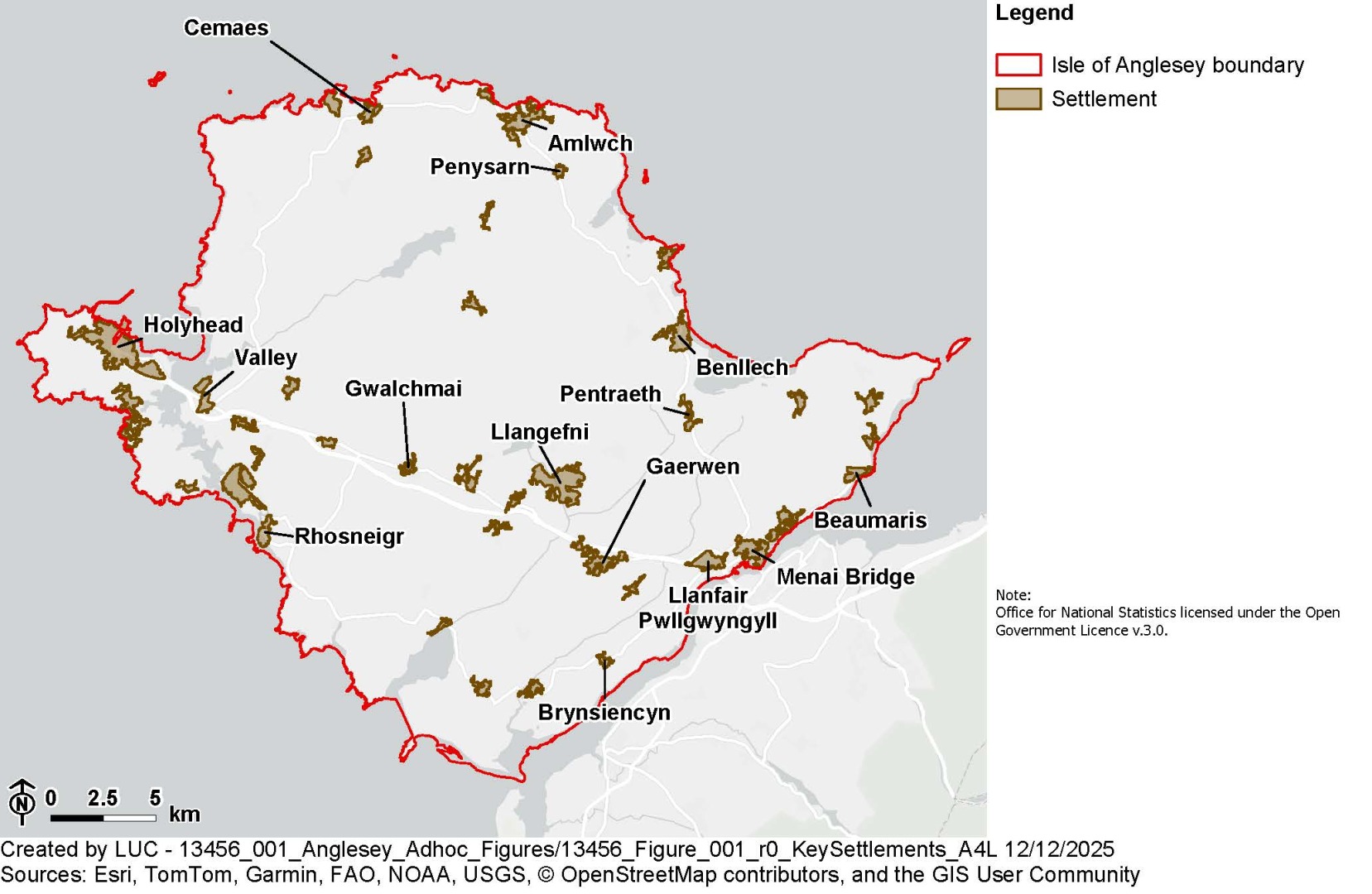
3.2 Key settlements and places
3.2.1 Anglesey is largely rural, with a number of key settlements. Holyhead (Caergybi) is the largest town and serves as a major international ferry port to Ireland, with attractions such as South Stack Lighthouse and Breakwater Country Park. Llangefni, located centrally, functions as the administrative centre and market town, offering business and retail services, alongside a further education college and growing industrial estates. It also hosts cultural sites like the Oriel Ynys Môn museum and the Dingle Nature Reserve. Amlwch, is a key local centre for North Anglesey, containing the only secondary school not near the A55. Once a hub of copper mining, it retains its industrial heritage through sites like the Copper Kingdom and Parys Mountain. It is the closest local centre to the Wylfa power station. Menai Bridge (Porthaethwy), situated on the Menai Strait, is known for its iconic suspension bridge and scenic waterfront. It contains a secondary school and is a centre for tourism.
3.2.1 Beaumaris is a picturesque seaside town, with a blend of medieval, Georgian, and Victorian architecture, home to the historic Beaumaris Castle. There are settlements associated with the railway stations on the Island at Llanfair and Valley. Gaerwen hosts a sizeable industrial estate.
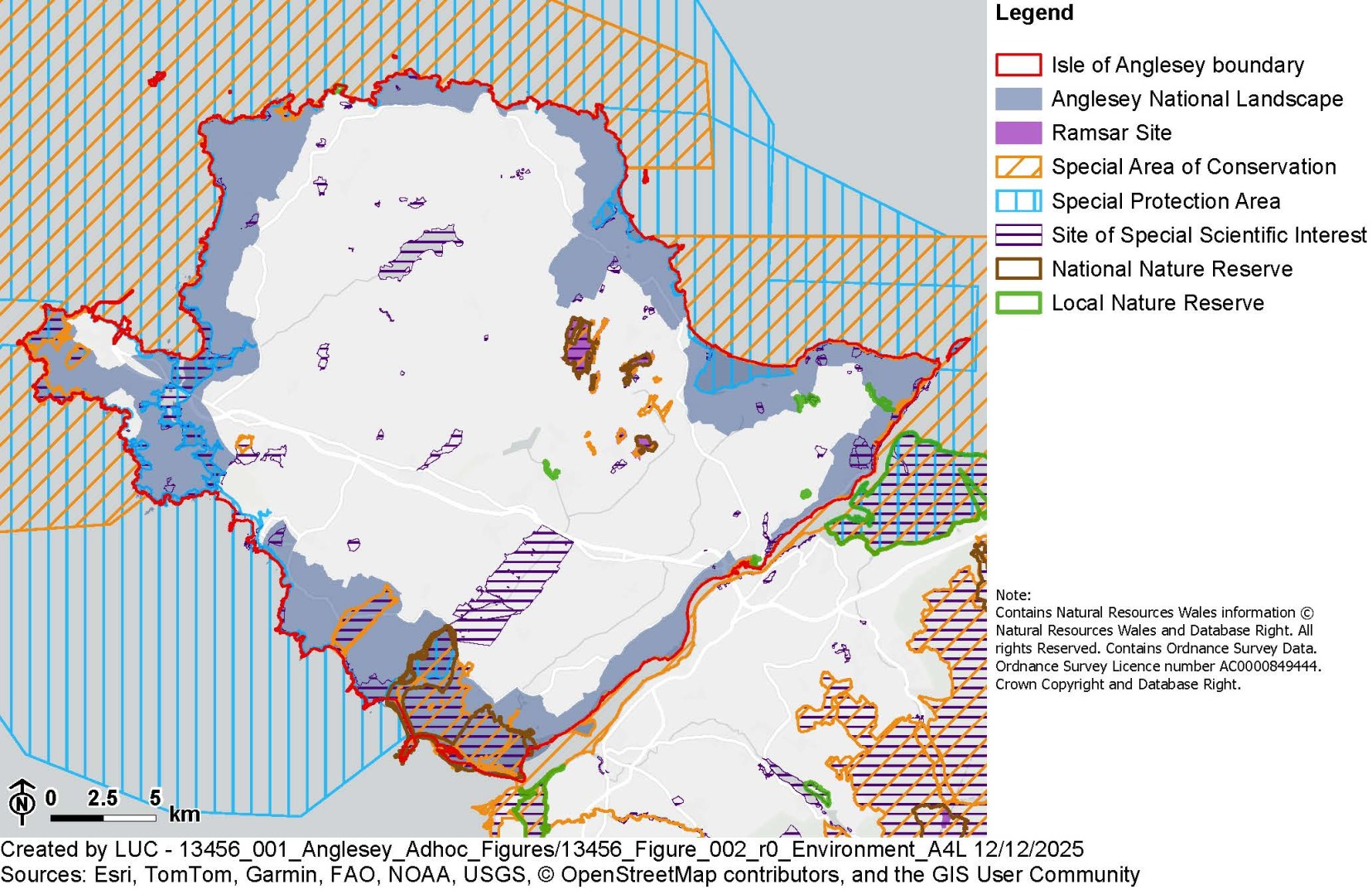
3.3 Environment
3.3.1 The Island’s environment is rich in biodiversity and is shaped by its varied landscapes and nature conservation designations. About one-third of Anglesey is designated as a National Landscape (formerly Area of Outstanding Natural Beauty). Coastal habitats include beaches and dunes at Newborough Warren and Aberffraw, cliffs and rocky shores along the north coast and Holy Island, and estuaries and saltmarshes in areas such as Malltraeth and Red Wharf Bay. Inland, agriculture dominates the land use, supported by the Island’s gently undulating terrain. Wetlands and rare calcareous fens, some protected as National Nature Reserves, add ecological value, while lakes like Llyn Alaw provide habitats for diverse wildlife.
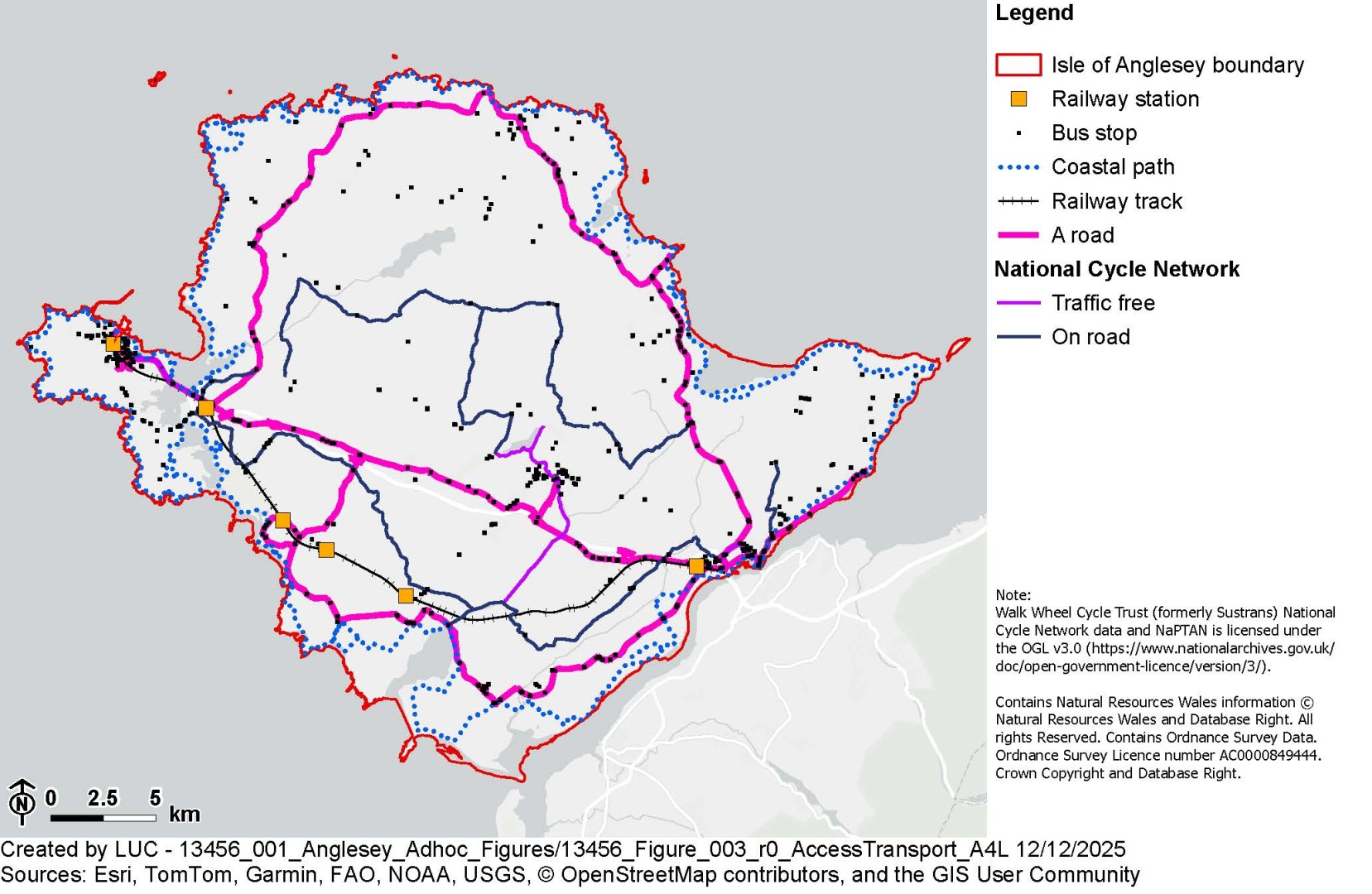
3.4 Access and Transport
3.4.1 Anglesey is well-connected to Ireland, primarily through its role as a port. Holyhead Port remains a vital ferry terminal, with regular services to Dublin operated by Stena Line and Irish Ferries.
3.4.2 The internal road network comprises A and B roads and country lanes. The Island is connected to the mainland via the Menai crossings (the Britannia Bridge, which carries the A55 and the railway, and the Menai Suspension Bridge, which carries the A5). The crossings are vital to island but have capacity issues, particularly at peak times. The limited nature of these crossings, and their capacity issues present a significant resilience risk to the Island.
3.4.3 Rail services run across the Island terminating at Holyhead - the end of the North Wales Coast Line. The route offers connections to London, Manchester, and Crewe. Bus services link the main towns but are less frequent in rural areas. Community transport schemes such as Car Linc Môn and the Seiriol Good Turn Scheme help support mobility for vulnerable residents. Due to limited public transport, residents often rely on private cars. Active travel is encouraged through over 1,000 kilometres of public rights of way (including the 125-mile Anglesey Coastal Path), alongside a cycling network that includes Lon Las Cefni, Lon Las Copr, and National Cycle Network Routes 5 and 8.
3.5 Population and demographics
3.5.1 According to the 2021 Census and mid-2022 estimates, Anglesey has a population of approximately 69,000. It is one of the least densely populated areas in Wales, with a density of 97 people per square kilometre. The demographic profile is notably older, with a median age of 49.3 years compared to the Welsh average of 42. The proportion of residents aged 65 and over stands at 26.5%, making it the fastest-growing age group. The working-age population has declined from 59.6% in 2011 to 56.3% in 2022. Ethnically, the population is predominantly white (98.1%), with 66.6% born in Wales. The Island saw the largest increase in residents identifying as “Welsh only” between 2011 and 2021. Anglesey is well-connected to Ireland, primarily through its role as a port. Holyhead Port remains a vital ferry terminal, with regular services to Dublin operated by Stena Line and Irish Ferries.
3.6 Welsh Language
3.6.1 Anglesey is a stronghold of the Welsh language. Welsh language proficiency remains strong, with the census identifying that 55.8% of residents are able to speak Welsh, although this marks a slight decline from 57.2% in 2011. This decline is primarily as a result of a loss of Welsh speaking working age people and a gaining on non-Welsh speaking older people. Encouragingly, there has been growth in Welsh-speaking ability among younger adults, particularly in areas such as Newborough, Beaumaris, and Holyhead.
3.7 Economy
3.7.1 Economically, Anglesey is shaped by seasonal sectors like tourism and agriculture, a significant public sector presence, and its strategic role as a ferry gateway. Tourism and hospitality are the largest employers, drawing 1.7 million visitors annually, though the sector is highly seasonal. The public sector remains the most stable employer, albeit limited in scope. Holyhead Port supports a range of transport and logistics businesses. Agriculture continues to play an important role, though it is generally lower-paid. The Island is also positioning itself as an “Energy Island,” promoting nuclear, tidal, and off shore wind energy initiatives, with future nuclear projects planned following the decommissioning of Wylfa. Manufacturing has declined, marked by the closure of Anglesey Aluminium. A major strategic development is the designation of Anglesey as a Freeport, aimed at attracting investment and driving economic regeneration.